1900s (20th Century) Maps of Jackson, Minnesota
Explore 8 historic maps of Jackson from the 1900s (20th Century). These maps offer a rare glimpse into what life looked like during the 1900s — showing old roads, neighborhoods, homes, and landmarks that have changed or disappeared over time.
Whether you're researching your family's past, planning a metal detecting trip, or studying how Jackson's landscape evolved across the 1900s, these high-resolution maps are a powerful tool for exploring the history of this region.
- Focus on a specific era: All maps on this page are from the 1900s, giving you a focused view of this time period.
- See what’s changed: Compare century-old streets, trails, and buildings to today's modern landscape using overlays and satellite layers.
- Research with precision: Use these maps for genealogy, historical research, land use analysis, or educational projects.
- View, download, or print: Maps are fully viewable online in high resolution, and can be downloaded or printed for your own records.
Start exploring Jackson's history through authentic maps from the 1900s. This is your window into the past.
Jackson, MN maps
(8)- 1954 Map of Fairmont, 1967 Print
 1954 Fairmont1967 Print · USGSThe prairie landscape of southern Minnesota and northern Iowa comes alive in this mid-century survey of the Coteau des Prairies. Genealogists and historians can trace the rail-connected growth of Fairmont and Blue Earth or locate family roots near St Kilian Ch and Union Slough National Wildlife Refuge.3 unique versions available
 - 1958 Map of Fairmont
 1958 Fairmont1958 Print · USGSThe borderlands of southern Minnesota and northern Iowa come alive in the mid-1950s, showing a landscape defined by glacial lakes and rail-line commerce. Researchers can trace historic landmarks like Lakeside Laboratory, Gridley Station, and the Bancroft Wildlife Refuge across the prairie.
 - 1970 Map of Jackson NW, 1972 Print
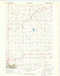 1970 Jackson NW1972 Print · USGSJackson and its surrounding townships are captured here during a period of agricultural and infrastructure expansion in the early seventies. Genealogists and local historians can trace family land in Enterprise, locate the Mennonite Ch, or survey the early grounds of the Jackson Municipal Airport.
 - 1970 Map of Lakefield NE, 1972 Print
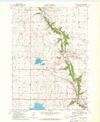 1970 Lakefield NE1972 Print · USGSJackson County's rural landscape is captured here in the early seventies, dominated by the winding Des Moines River valley. Genealogists can locate family landmarks like Belmont Ch and the East Belmont Cem near the Chicago Milwaukee St Paul and Pacific rail line.2 unique versions available
 - 1970 Map of Jackson, 1972 Print
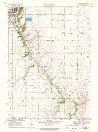 1970 Jackson1972 Print · USGSJackson and the Des Moines River valley appear here in the early seventies as the region balanced its role as a county seat with a river-based economy. Researchers can locate several family burial sites including Riverside and Petersburg Cem, alongside local landmarks like the Powerplant and Getty Park.
 - 1970 Map of Lakefield SE, 1972 Print
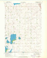 1970 Lakefield SE1972 Print · USGSThe Minnesota-Iowa borderlands appear here in the early seventies, dominated by the drainage networks of the Des Moines River valley. Genealogists and local historians can trace the early layout of Jackson, locate the Vocational Sch, and find the rural Townhall in Middletown.
 - 1985 Map of Worthington
 1985 Worthington1985 Print · USGSSouthwestern Minnesota and northwestern Iowa are captured in the mid-1980s, showcasing the high-water mark of the region's agricultural and rail-line infrastructure. Researchers can trace the path of the Chicago and North Western through prairie towns like Adrian, Wilmont, and Lakefield.2 unique versions available
 - 1985 Map of Fairmont, 1991 Print
 1985 Fairmont1991 Print · USGSSouthern Minnesota in the mid-eighties shows a robust network of prairie towns and rail-connected agricultural hubs. Genealogists can trace family footprints across Rolling Green and Manyaska or locate old homesteads near Fox Lake and the Chicago & North Western line.
End of results
Showing maps 1-8 of 8
Top cities near Jackson
- Estherville historical maps
- Spirit Lake historical maps
- Lakefield historical maps
- Okoboji historical maps
- Orleans historical maps
- Petersburg historical maps
See more
Top neighborhoods of Jackson
Frequently asked questions
- What are the different types of historical maps available for Jackson?
- What is the oldest map of Jackson?
- Where can I purchase historical maps of Jackson for my home or office?
- Where can I download high-res historical maps of Jackson?
- Are there historical topographic maps available for Jackson?
- Is there historical aerial imagery available for Jackson?
- Where are historical maps of Jackson sourced from?