1970s Maps of Littlefork, Minnesota
Explore 2 historic maps of Littlefork from the 1970s. These maps offer a rare glimpse into what life looked like during the 1970s — showing old roads, neighborhoods, homes, and landmarks that have changed or disappeared over time.
Whether you're researching your family's past, planning a metal detecting trip, or studying how Littlefork's landscape evolved across the 1970s, these high-resolution maps are a powerful tool for exploring the history of this region.
- Focus on a specific era: All maps on this page are from the 1970s, giving you a focused view of this time period.
- See what’s changed: Compare century-old streets, trails, and buildings to today's modern landscape using overlays and satellite layers.
- Research with precision: Use these maps for genealogy, historical research, land use analysis, or educational projects.
- View, download, or print: Maps are fully viewable online in high resolution, and can be downloaded or printed for your own records.
Start exploring Littlefork's history through authentic maps from the 1970s. This is your window into the past.
Littlefork, MN maps
(2)- 1970 Map of Littlefork, 1973 Print
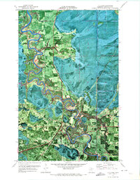 1970 Littlefork1973 Print · USGSLittlefork and its surrounding Koochiching County forests are captured in the early 1970s as a hub for timber and river transit. Trace the winding Little Fork River past the Burlington Northern line and Northwood Chapel.
 - 1978 Map of Littlefork, 1994 Print
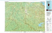 1978 Littlefork1994 Print · USGSNorthern Minnesota’s timber and river country is captured here in the late seventies, showing the vast forest lands before modern development. Genealogists and historians can trace the Minnesota Dakota and Western RR through Littlefork and locate remote lookouts like Fort Lookout Tower.
End of results
Showing maps 1-2 of 2
Top cities near Littlefork
Frequently asked questions
- What are the different types of historical maps available for Littlefork?
- What is the oldest map of Littlefork?
- Where can I purchase historical maps of Littlefork for my home or office?
- Where can I download high-res historical maps of Littlefork?
- Are there historical topographic maps available for Littlefork?
- Is there historical aerial imagery available for Littlefork?
- Where are historical maps of Littlefork sourced from?