1950s Maps of Silver Creek Township, Minnesota
Explore 11 historic maps of Silver Creek Township from the 1950s. These maps offer a rare glimpse into what life looked like during the 1950s — showing old roads, neighborhoods, homes, and landmarks that have changed or disappeared over time.
Whether you're researching your family's past, planning a metal detecting trip, or studying how Silver Creek Township's landscape evolved across the 1950s, these high-resolution maps are a powerful tool for exploring the history of this region.
- Focus on a specific era: All maps on this page are from the 1950s, giving you a focused view of this time period.
- See what’s changed: Compare century-old streets, trails, and buildings to today's modern landscape using overlays and satellite layers.
- Research with precision: Use these maps for genealogy, historical research, land use analysis, or educational projects.
- View, download, or print: Maps are fully viewable online in high resolution, and can be downloaded or printed for your own records.
Start exploring Silver Creek Township's history through authentic maps from the 1950s. This is your window into the past.
Silver Creek Township, MN maps
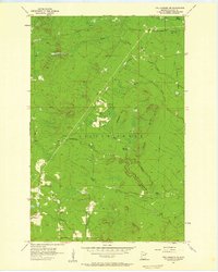
(11)- 1953 Map of Whyte, 1955 Print
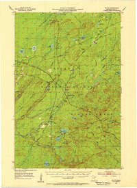 1953 Whyte1955 Print · USGSThe Superior National Forest was a hub of rail-driven industry in the early fifties, crisscrossed by specialized ore and logging lines. Researchers can trace the junctions of the Duluth Missabe and Iron Range Railroad near Whyte and McNair, or locate landmarks like the Lookout Tower on Mt Weber.3 unique versions available
 - 1954 Map of Silver Bay, 1956 Print
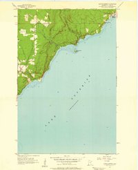
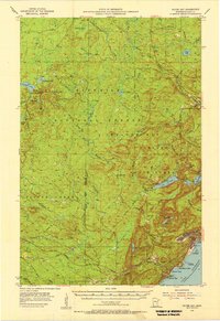 1954 Silver Bay1956 Print · USGSThe North Shore was undergoing industrial expansion in the mid-1950s as mining and maritime logistics converged on the Lake Superior coast. Researchers can trace the early infrastructure of Silver Bay, the operations at the Mining site, and old logging routes like the Old Company Railroad.3 unique versions available
 - 1954 Map of Two Harbors, 1964 Print
 1954 Two Harbors1964 Print · USGSThe Minnesota North Shore and Superior National Forest are shown here in the mid-fifties, just as the taconite industry was reshaping the coast. Genealogists and historians can trace the rail lines of the Duluth Missabe and Iron Range or locate remote outposts like Sawbill Landing and Section Thirty.2 unique versions available
 - 1956 Map of Split Rock Point, 1958 Print
 1956 Split Rock Point1958 Print · USGSThe Lake Superior shoreline comes alive in the mid-fifties, capturing the rugged North Shore before modern expansion. Trace the Old Railroad Grade and explore early coastal landmarks like Little Two Harbors, Castle Danger, and the falls of Gooseberry Falls State Park.3 unique versions available
 - 1956 Map of Split Rock Point, 1958 Print
 1956 Split Rock Point1958 Print · USGSThe North Shore of Lake Superior during the mid-fifties is captured here, showing the era's balance of industry and tourism. Trace the Old RR Grade and maritime landmarks like the Split Rock Lighthouse and Castle Danger.2 unique versions available
 - 1957 Map of Two Harbors
 1957 Two Harbors1957 Print · USGSMinnesota's North Shore and the Arrowhead region are shown here in the mid-fifties as the taconite industry and cold war defense shaped the landscape. Researchers can trace the Duluth Missabe and Iron Range railroad, locate the Split Rock Light, and explore the iron-mining era at Taconite.
 - 1957 Map of Two Harbors, 1958 Print
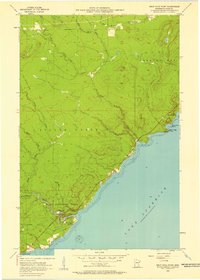
 1957 Two Harbors1958 Print · USGSThe North Shore harbor of Two Harbors and its iron-ore rail connections are captured here during the mid-fifties. Genealogists and historians can trace coastal life from the Lighthouse at Agate Bay to inland settlements like Waldo, Alger, and the Johnson School.2 unique versions available
 - 1957 Map of Two Harbors, 1958 Print
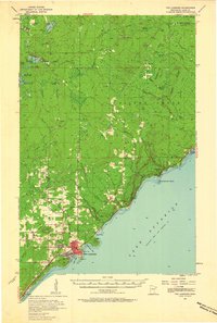
 1957 Two Harbors1958 Print · USGSThe Lake Superior shoreline at Two Harbors is captured here in the late fifties, dominated by the vital iron-ore shipping works. Researchers can trace the massive Duluth Missabe and Iron Range Railroad yards, locate the Lighthouse, or find old schools like Johnson Sch.2 unique versions available
 - 1957 Map of Two Harbors NE, 1958 Print
 1957 Two Harbors NE1958 Print · USGSLake County north of the North Shore comes into focus in the 1950s, showing a landscape defined by timber history and drainage networks. Genealogists and researchers can trace the Old Railroad Grade through the woods and locate sites like London, Beaver Crossing, and the Bud Hill Lookout Tower.3 unique versions available
 - 1957 Map of Castle Danger, 1958 Print
 1957 Castle Danger1958 Print · USGSThe North Shore of Lake Superior comes into focus in the late fifties, capturing the community of Castle Danger and the winding course of Highway 61. Trace the coastal topography of Silver Cliff or locate local landmarks like Our Saviours Ch and Encampment Island.2 unique versions available
 - 1958 Map of Two Harbors
 1958 Two Harbors1958 Print · USGSThe North Shore and Arrowhead region of Minnesota are captured in the 1950s as iron ore shipping and wilderness preservation shaped the land. Researchers can trace the Duluth Missabe and Iron Range RR, find maritime landmarks like Split Rock Light, and locate remote settlements from Babbitt to Grand Marais.
End of results
Showing maps 1-11 of 11
Top cities near Silver Creek Township
- Two Harbors historical maps
- Silver Bay historical maps
- Silver Creek historical maps
- Beaver Bay historical maps
Top neighborhoods of Silver Creek Township
- London historical maps
- Whyte historical maps
- Jordan historical maps
- Beaver Crossing historical maps
- Darby Junction historical maps
- Castle Danger historical maps
See more
Frequently asked questions
- What are the different types of historical maps available for Silver Creek Township?
- What is the oldest map of Silver Creek Township?
- Where can I purchase historical maps of Silver Creek Township for my home or office?
- Where can I download high-res historical maps of Silver Creek Township?
- Are there historical topographic maps available for Silver Creek Township?
- Is there historical aerial imagery available for Silver Creek Township?
- Where are historical maps of Silver Creek Township sourced from?