1980s Maps of Silver Creek Township, Minnesota
Explore 7 historic maps of Silver Creek Township from the 1980s. These maps offer a rare glimpse into what life looked like during the 1980s — showing old roads, neighborhoods, homes, and landmarks that have changed or disappeared over time.
Whether you're researching your family's past, planning a metal detecting trip, or studying how Silver Creek Township's landscape evolved across the 1980s, these high-resolution maps are a powerful tool for exploring the history of this region.
- Focus on a specific era: All maps on this page are from the 1980s, giving you a focused view of this time period.
- See what’s changed: Compare century-old streets, trails, and buildings to today's modern landscape using overlays and satellite layers.
- Research with precision: Use these maps for genealogy, historical research, land use analysis, or educational projects.
- View, download, or print: Maps are fully viewable online in high resolution, and can be downloaded or printed for your own records.
Start exploring Silver Creek Township's history through authentic maps from the 1980s. This is your window into the past.
Silver Creek Township, MN maps
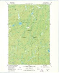
(7)- 1981 Map of Legler Lake, 1982 Print
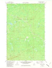 1981 Legler Lake1982 Print · USGSLake County's timber and mining country is captured here in the early eighties as industrial transport lines moved through the wilderness. You can trace the path of the Mining Railroad or locate local landmarks like Legler Lake and Water Tank Lake.2 unique versions available
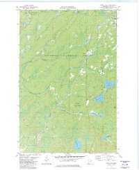
 - 1981 Map of Highland, 1982 Print
 1981 Highland1982 Print · USGSLake County's North Shore backcountry is shown in the early eighties, centered on the vital iron ore transit corridor. Genealogists and local historians can trace the small settlements of Highland, Wales, and Alger along the Duluth Missabe and Iron Range Railroad.
 - 1981 Map of Kane Lake, 1982 Print
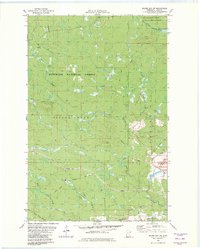
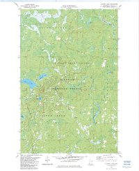
 1981 Kane Lake1982 Print · USGSLake County timber and rail operations are captured here in the early eighties, showing the deep woods near the Duluth Missabe and Iron Range Railroad. Trace the old rail stop at Norshor Junction or the remote outpost at McNair near Kane Lake.2 unique versions available
 - 1982 Map of Silver Bay SW
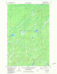
 1982 Silver Bay SW1982 Print · USGSLake County's forested interior is captured here in the early 1980s, showcasing a landscape shaped by both timber and mining interests. Researchers can trace the path of the Mining Railroad and an Old Railroad Grade or locate the Silver Bay Municipal Airport near the Beaver River.2 unique versions available
 - 1982 Map of Mt Weber
 1982 Mt Weber1982 Print · USGSLake County's timber and iron country is detailed here in the early eighties, showcasing the intersection of industrial rail and protected forests. Researchers can trace the paths of the Duluth Missabe and Iron Range and an Old RR Grade near Sullivan Lake.2 unique versions available
 - 1982 Map of Whyte
 1982 Whyte1982 Print · USGSLake County's timber and rail history is preserved here in the early 1980s, centered on the intersection of the Finland State Forest and the Superior National Forest. You can trace the Duluth Missabe and Iron Range tracks through Whyte and Scott Junction or locate an Old Railroad Grade.2 unique versions available
 - 1982 Map of Cloquet Lake, 1983 Print
 1982 Cloquet Lake1983 Print · USGSThe Lake County wilderness in the early 1980s reveals a landscape of protected forests and interconnected waterways. Outdoor researchers and local historians can trace the paths of a Winter Trail and Heffelfinger Road through the Finland State Forest.2 unique versions available
End of results
Showing maps 1-7 of 7
Top cities near Silver Creek Township
- Two Harbors historical maps
- Silver Bay historical maps
- Silver Creek historical maps
- Beaver Bay historical maps
Top neighborhoods of Silver Creek Township
- London historical maps
- Whyte historical maps
- Jordan historical maps
- Beaver Crossing historical maps
- Darby Junction historical maps
- Castle Danger historical maps
See more
Frequently asked questions
- What are the different types of historical maps available for Silver Creek Township?
- What is the oldest map of Silver Creek Township?
- Where can I purchase historical maps of Silver Creek Township for my home or office?
- Where can I download high-res historical maps of Silver Creek Township?
- Are there historical topographic maps available for Silver Creek Township?
- Is there historical aerial imagery available for Silver Creek Township?
- Where are historical maps of Silver Creek Township sourced from?