1910s Maps of Birch Beach, Minnesota
Explore 1 historic maps of Birch Beach from the 1910s. These maps offer a rare glimpse into what life looked like during the 1910s — showing old roads, neighborhoods, homes, and landmarks that have changed or disappeared over time.
Whether you're researching your family's past, planning a metal detecting trip, or studying how Birch Beach's landscape evolved across the 1910s, these high-resolution maps are a powerful tool for exploring the history of this region.
- Focus on a specific era: All maps on this page are from the 1910s, giving you a focused view of this time period.
- See what’s changed: Compare century-old streets, trails, and buildings to today's modern landscape using overlays and satellite layers.
- Research with precision: Use these maps for genealogy, historical research, land use analysis, or educational projects.
- View, download, or print: Maps are fully viewable online in high resolution, and can be downloaded or printed for your own records.
Start exploring Birch Beach's history through authentic maps from the 1910s. This is your window into the past.
Birch Beach, MN maps
(1)- 1918 Map of Williams
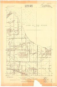 1918 Williams1918 Print · USGSBeltrami County's northern frontier comes to life just before the end of the Great War as surveyors documented the drainage and settlement of this timbered landscape. Trace early infrastructure along the Canadian Northern rail line and explore the complex system of drainage works including Main Judicial Ditch No 24 and Judicial Ditch No 16.
End of results
Showing maps 1-1 of 1
Top cities near Birch Beach
Frequently asked questions
- What are the different types of historical maps available for Birch Beach?
- What is the oldest map of Birch Beach?
- Where can I purchase historical maps of Birch Beach for my home or office?
- Where can I download high-res historical maps of Birch Beach?
- Are there historical topographic maps available for Birch Beach?
- Is there historical aerial imagery available for Birch Beach?
- Where are historical maps of Birch Beach sourced from?