1900s (20th Century) Maps of Montgomery Township, Minnesota
Explore 7 historic maps of Montgomery Township from the 1900s (20th Century). These maps offer a rare glimpse into what life looked like during the 1900s — showing old roads, neighborhoods, homes, and landmarks that have changed or disappeared over time.
Whether you're researching your family's past, planning a metal detecting trip, or studying how Montgomery Township's landscape evolved across the 1900s, these high-resolution maps are a powerful tool for exploring the history of this region.
- Focus on a specific era: All maps on this page are from the 1900s, giving you a focused view of this time period.
- See what’s changed: Compare century-old streets, trails, and buildings to today's modern landscape using overlays and satellite layers.
- Research with precision: Use these maps for genealogy, historical research, land use analysis, or educational projects.
- View, download, or print: Maps are fully viewable online in high resolution, and can be downloaded or printed for your own records.
Start exploring Montgomery Township's history through authentic maps from the 1900s. This is your window into the past.
Montgomery Township, MN maps
(7)- 1953 Map of Saint Paul, 1964 Print
 1953 Saint Paul1964 Print · USGSThe Twin Cities and the Mississippi River valley are captured here at a mid-century turning point. Trace the early growth of Minneapolis and Saint Paul alongside landmarks like Lake Minnetonka and the St Croix River.4 unique versions available
 - 1959 Map of Saint Paul
 1959 Saint Paul1959 Print · USGSThe Twin Cities and southeastern Minnesota appear here in the late fifties, showing the peak of the rail era and post-war suburban growth. Genealogists can trace family footprints near Lake Minnetonka, the Univ Of Minn Rosemount Research Center, or the growing neighborhoods of Richfield.2 unique versions available
 - 1966 Map of Montgomery, 1967 Print
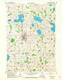 1966 Montgomery1967 Print · USGSLe Sueur and Rice counties are captured here in the mid-sixties, centered on the rail hub of Montgomery. Genealogists and local historians can trace family roots through numerous sites like Bohemian Cem, St Michael Cem, and the old High School.2 unique versions available
 - 1966 Map of Cordova, 1968 Print
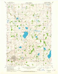
 1966 Cordova1968 Print · USGSLe Sueur County was a landscape of glacial lakes and managed wildlife areas in the mid-sixties. Genealogists and researchers can trace family landmarks like St Peters Ch, Gorman Cem, and the old settlement of Cordova.2 unique versions available
 - 1966 Map of Le Center, 1968 Print
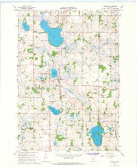
 1966 Le Center1968 Print · USGSThe township boundaries of southern Minnesota meet here during the mid-sixties, centered on the hub of Le Center. Genealogists and local historians can trace the sites of Yankee Cem, St John Ch, and the winding Milwaukee Road railroad line.2 unique versions available
 - 1966 Map of Kilkenny, 1968 Print
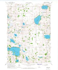
 1966 Kilkenny1968 Print · USGSThe lake-dotted landscape of Le Sueur County is captured here in the mid-1960s, centered on the railroad town of Kilkenny. Researchers can trace old family lines near Calvary Cem and locate historic hamlets like Doyle and Rogers along the rail line.2 unique versions available
 - 1985 Map of Faribault, 1986 Print
 1985 Faribault1986 Print · USGSThe Minnesota River valley and the glacial lake country of Rice and Le Sueur counties are shown here in the mid-1980s. Researchers can trace the academic grounds of St Olaf College or find old crossroads like Trondhjem and Little Chicago.2 unique versions available
End of results
Showing maps 1-7 of 7
Top cities near Montgomery Township
- New Prague historical maps
- Credit River historical maps
- Belle Plaine historical maps
- Elko New Market historical maps
- Montgomery historical maps
- Lonsdale historical maps
See more
Top neighborhoods of Montgomery Township
Frequently asked questions
- What are the different types of historical maps available for Montgomery Township?
- What is the oldest map of Montgomery Township?
- Where can I purchase historical maps of Montgomery Township for my home or office?
- Where can I download high-res historical maps of Montgomery Township?
- Are there historical topographic maps available for Montgomery Township?
- Is there historical aerial imagery available for Montgomery Township?
- Where are historical maps of Montgomery Township sourced from?