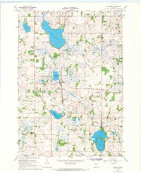
1966 Map of Kilkenny
USGS Topo · Published 1968About this map
The town of Kilkenny anchors this mid-century survey of the Minnesota lake country, situated at a junction where the Chicago and North Western railroad cuts between Lake Dora and Diamond Lake. The landscape is defined by its glaciated hydrology, featuring numerous wetlands and named basins such as Sunfish Lake, Goose Lake, and Lake Mabel. These waters are linked by the Cannon River and its tributary, the Little Cannon River, which flow through a mix of agricultural land and managed natural spaces.
Find a feature on this map
23 named features on this map. Tap any name to fly to it.
Don’t see what you’re looking for? This feature index may not catch every label — zoom into the map to look around manually.
Map Details
Editions of this 1966 Kilkenny Map
2 editions found
Other maps of this area

1953 · Saint Paul
USGS Topo · 1:250,000

1959 · Saint Paul
USGS Topo · 1:250,000

1960 · Shieldsville
USGS Topo · 1:24,000

1960 · Lonsdale
USGS Topo · 1:24,000

1962 · Morristown
USGS Topo · 1:24,000

1966 · Montgomery
USGS Topo · 1:24,000

1966 · Waterville
USGS Topo · 1:24,000

1966 · Cordova
USGS Topo · 1:24,000

1966 · Elysian
USGS Topo · 1:24,000

1966 · Le Center
USGS Topo · 1:24,000