
1966 Map of Montgomery
USGS Topo · Published 1967About this map
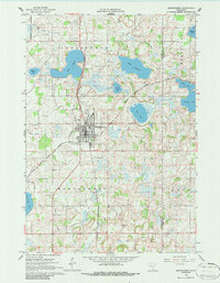
Montgomery serves as the central hub of this mid-1960s survey, situated at the junction of two major rail lines. The Chicago and North Western runs north-south through the center of town, while the Chicago Milwaukee St Paul and Pacific cuts diagonally across the township. This transportation network supported a landscape dotted with numerous lakes and agricultural operations, as evidenced by the presence of a Gravel Pit and a widespread drainage system of county ditches.
Find a feature on this map
28 named features on this map. Tap any name to fly to it.
Don’t see what you’re looking for? This feature index may not catch every label — zoom into the map to look around manually.
Map Details
Editions of this 1966 Montgomery Map
2 editions found
Other maps of this area

1953 · Saint Paul
USGS Topo · 1:250,000

1957 · Prior Lake
USGS Topo · 1:62,500

1957 · New Prague
USGS Topo · 1:62,500

1959 · Saint Paul
USGS Topo · 1:250,000

1960 · Shieldsville
USGS Topo · 1:24,000

1960 · Lonsdale
USGS Topo · 1:24,000

1966 · Cordova
USGS Topo · 1:24,000

1966 · Le Center
USGS Topo · 1:24,000
1966 · Kilkenny
USGS Topo · 1:24,000
1974 · Veseli
USGS Topo · 1:24,000