2020s Maps of Ottawa Township, Minnesota
Explore 2 historic maps of Ottawa Township from the 2020s. These maps offer a rare glimpse into what life looked like during the 2020s — showing old roads, neighborhoods, homes, and landmarks that have changed or disappeared over time.
Whether you're researching your family's past, planning a metal detecting trip, or studying how Ottawa Township's landscape evolved across the 2020s, these high-resolution maps are a powerful tool for exploring the history of this region.
- Focus on a specific era: All maps on this page are from the 2020s, giving you a focused view of this time period.
- See what’s changed: Compare century-old streets, trails, and buildings to today's modern landscape using overlays and satellite layers.
- Research with precision: Use these maps for genealogy, historical research, land use analysis, or educational projects.
- View, download, or print: Maps are fully viewable online in high resolution, and can be downloaded or printed for your own records.
Start exploring Ottawa Township's history through authentic maps from the 2020s. This is your window into the past.
Ottawa Township, MN maps
(2)- 2022 Map of Le Sueur, 2022 Print
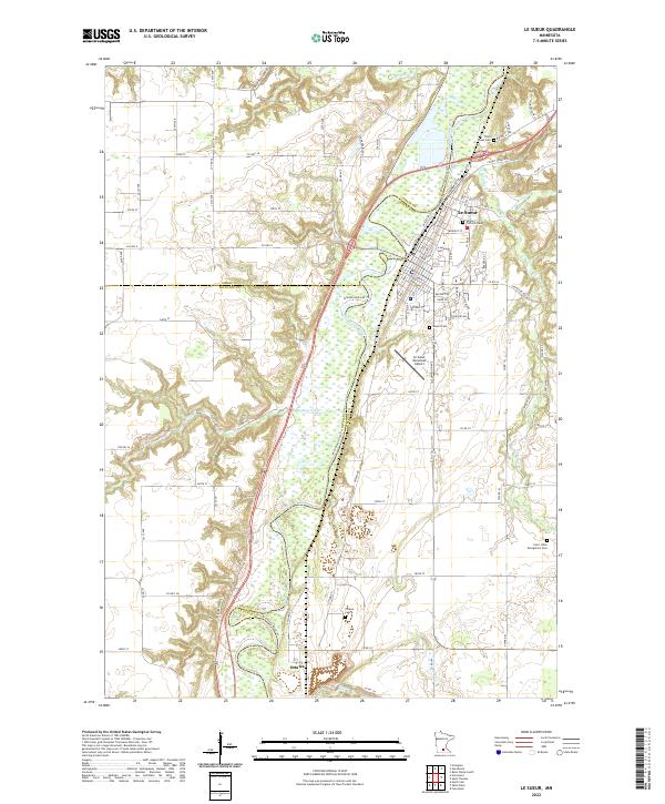 2022 Le Sueur2022 Print · USGSThe Minnesota River valley near Le Sueur comes alive in this 2022 survey, showcasing the enduring rail and river corridor. Genealogists can locate several historic burial sites, including Ottawa Cem, Mound Cem, and the Saint Annes Cem.
 - 2022 Map of Saint Peter, 2022 Print
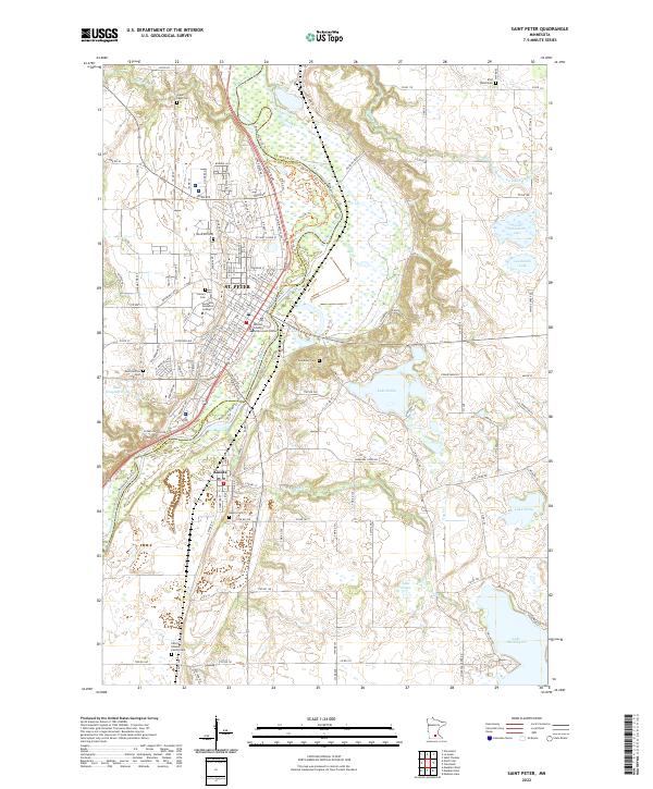 2022 Saint Peter2022 Print · USGSSt. Peter and Kasota are shown at the height of their modern development along the Minnesota River valley. Researchers can trace local heritage through numerous sites like Gustavus Adolphus College, Elim Welsh Cem, and the Nicollet County Government Center.
End of results
Showing maps 1-2 of 2
Top cities near Ottawa Township
- Mankato historical maps
- North Mankato historical maps
- Saint Peter historical maps
- Belle Plaine historical maps
- Le Sueur historical maps
- Le Center historical maps
See more
Top neighborhoods of Ottawa Township
Frequently asked questions
- What are the different types of historical maps available for Ottawa Township?
- What is the oldest map of Ottawa Township?
- Where can I purchase historical maps of Ottawa Township for my home or office?
- Where can I download high-res historical maps of Ottawa Township?
- Are there historical topographic maps available for Ottawa Township?
- Is there historical aerial imagery available for Ottawa Township?
- Where are historical maps of Ottawa Township sourced from?