1900s (20th Century) Maps of Tracy, Minnesota
Explore 8 historic maps of Tracy from the 1900s (20th Century). These maps offer a rare glimpse into what life looked like during the 1900s — showing old roads, neighborhoods, homes, and landmarks that have changed or disappeared over time.
Whether you're researching your family's past, planning a metal detecting trip, or studying how Tracy's landscape evolved across the 1900s, these high-resolution maps are a powerful tool for exploring the history of this region.
- Focus on a specific era: All maps on this page are from the 1900s, giving you a focused view of this time period.
- See what’s changed: Compare century-old streets, trails, and buildings to today's modern landscape using overlays and satellite layers.
- Research with precision: Use these maps for genealogy, historical research, land use analysis, or educational projects.
- View, download, or print: Maps are fully viewable online in high resolution, and can be downloaded or printed for your own records.
Start exploring Tracy's history through authentic maps from the 1900s. This is your window into the past.
Tracy, MN maps
(8)- 1953 Map of New Ulm, 1968 Print
 1953 New Ulm1968 Print · USGSSouthern Minnesota in the mid-1950s is defined by its deep river valleys and the expanding reach of the Great Northern and Chicago and North Western railroads. Researchers can trace rural lineages through landmarks like the Milford State Monument, St. John's Ch, and the Upper Sioux Indian Res.3 unique versions available
 - 1957 Map of New Ulm
 1957 New Ulm1957 Print · USGSCentral Minnesota in the mid-fifties remains a landscape of river-valley commerce and prairie agriculture defined by its historic mission sites and rail towns. Genealogists and local historians can trace the development of New Ulm and Montevideo, or locate specific landmarks like the Milford State Monument and Minnesota Falls.
 - 1958 Map of New Ulm
 1958 New Ulm1958 Print · USGSSouth-central Minnesota’s river valleys and prairie towns are captured here in the mid-fifties, during the height of the region's rail-and-river economy. Genealogists and historians can trace the legacy of the Upper Sioux Indian Mission or locate early rail stops along the Chicago and North Western Ry in towns like Redwood Falls and Glencoe.
 - 1962 Map of Milroy SE, 1964 Print
 1962 Milroy SE1964 Print · USGSSouthwestern Minnesota prairie lands are captured here in the early sixties, showing the agricultural heart of the Redwood and Lyon county line. Researchers can locate family roots at several burial sites including Gales Cem, Luther Cem, and Swedish Cem.
 - 1967 Map of New Ulm
 1967 New Ulm1967 Print · USGSSouthern Minnesota in the mid-fifties is captured here as a landscape of river-valley missions and busy prairie rail towns. Researchers can trace the Yellow Medicine Trail and locate historic sites like the Morton Indian Mission and Milford State Monument.
 - 1967 Map of Tracy East, 1968 Print
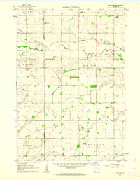
 1967 Tracy East1968 Print · USGSMurray and Redwood Counties are shown in detail during the late sixties as agricultural development shaped the Minnesota prairie. Researchers can locate family landmarks like Tracy Cemetery, follow the Plum Creek drainage, and find rural hubs such as Holly Ch.
 - 1967 Map of Tracy West, 1968 Print
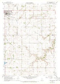
 1967 Tracy West1968 Print · USGSSouthwestern Minnesota's prairie and lake country is captured here in the late sixties as the city of Tracy thrives along the railroad. Researchers can locate rural landmarks like Holland Cem, the Rialson Cem, and various shoreline features around Lake Sarah.2 unique versions available
 - 1986 Map of Tracy
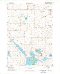
 1986 Tracy1986 Print · USGSSouthwestern Minnesota's prairie rail towns and conservation lands are captured here in the mid-1980s. Researchers can trace the Chicago and North Western line through Walnut Grove or explore the many lakebeds and wildlife areas like Lake Sarah and Lake Shetek State Park.2 unique versions available
End of results
Showing maps 1-8 of 8
Top cities near Tracy
- Marshall historical maps
- Walnut Grove historical maps
- Milroy historical maps
- Amiret historical maps
- Currie historical maps
- Lucan historical maps
See more
Top neighborhoods of Tracy
Frequently asked questions
- What are the different types of historical maps available for Tracy?
- What is the oldest map of Tracy?
- Where can I purchase historical maps of Tracy for my home or office?
- Where can I download high-res historical maps of Tracy?
- Are there historical topographic maps available for Tracy?
- Is there historical aerial imagery available for Tracy?
- Where are historical maps of Tracy sourced from?