1980s Maps of Meeker County, Minnesota
Explore 11 historic maps of Meeker County from the 1980s. These maps offer a rare glimpse into what life looked like during the 1980s — showing old roads, neighborhoods, homes, and landmarks that have changed or disappeared over time.
Whether you're researching your family's past, planning a metal detecting trip, or studying how Meeker County's landscape evolved across the 1980s, these high-resolution maps are a powerful tool for exploring the history of this region.
- Focus on a specific era: All maps on this page are from the 1980s, giving you a focused view of this time period.
- See what’s changed: Compare century-old streets, trails, and buildings to today's modern landscape using overlays and satellite layers.
- Research with precision: Use these maps for genealogy, historical research, land use analysis, or educational projects.
- View, download, or print: Maps are fully viewable online in high resolution, and can be downloaded or printed for your own records.
Start exploring Meeker County's history through authentic maps from the 1980s. This is your window into the past.
Meeker County, MN maps
(11)- 1982 Map of Dassel
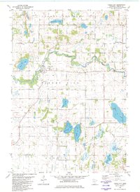
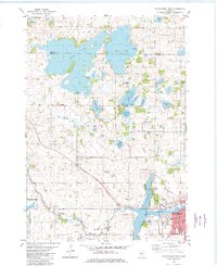
 1982 Dassel1982 Print · USGSDassel and the surrounding Minnesota lake country are captured here in the early 1980s as the rail and agricultural economy shaped the region. Researchers can locate family landmarks like Steelsville Cem or trace the shoreline developments of Lake Washington and Collinwood Lake.
 - 1982 Map of Forest City
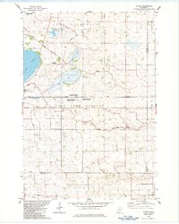
 1982 Forest City1982 Print · USGSMeeker County's river valleys and prairie lakes are captured here in the early eighties as the rural landscape of Forest City remained deeply rooted in its local parishes. Genealogists and local historians can locate St Gertrude Ch, the West Kingston Mission, and family landmarks near Richardson Lake.
 - 1982 Map of Darwin
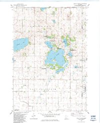
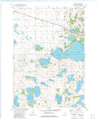 1982 Darwin1982 Print · USGSMeeker County is captured in the early eighties as a hub of lakeside living and rail transit near the village of Darwin. Genealogists and local historians can trace family sites at St Johns Cem, St Peters Ch, and the rural Townhall near Mud Lake.
 - 1982 Map of Kingston
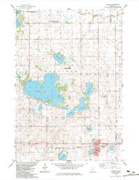
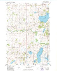 1982 Kingston1982 Print · USGSThe Meeker and Wright County borderlands in the early eighties show a landscape of glacial lakes and river bends. Researchers can trace family history through local sites like Riverside Cemetery or explore the banks of the North Fork Crow River near Kingston.
 - 1982 Map of Hutchinson East
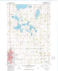 1982 Hutchinson East1982 Print · USGSMcLeod County is shown during a time of agricultural prominence and lakefront activity in the early eighties. Genealogists and local historians can trace family-named sites like St Anastasia Cem, the community of Lamson, and the Oakland Cemetery.2 unique versions available
 - 1982 Map of Hutchinson West
 1982 Hutchinson West1982 Print · USGSHutchinson and the surrounding Acoma Township are captured in the early eighties as the town expanded toward the Crow River. Genealogists and local researchers can locate the Acoma Cem, Immanuel Sch, and numerous family landmarks near Cedar Lake.2 unique versions available
 - 1982 Map of Thorpe, 1983 Print
 1982 Thorpe1983 Print · USGSSouthern Kandiyohi County was a patchwork of wetlands and managed farmland in the early 1980s. Genealogists and historians can trace family locations near Wagemaker and Swenson, or locate landmarks like the Lake Lillian Ch and the Luce Line State Trail.
 - 1982 Map of Lake Elizabeth, 1983 Print
 1982 Lake Elizabeth1983 Print · USGSThe glacial lakes and wetlands of Kandiyohi County are captured here in the early eighties as conservation areas expanded across the prairie. Researchers can trace local burial sites like Union Cem and Oak Grove Cem or find the rural Townhall.
 - 1983 Map of Atwater
 1983 Atwater1983 Print · USGSThe lakeside township of Atwater and its surrounding farm country are captured here in the early eighties. Genealogists and local historians can trace family plots at Bethlehem Cem or Oakside Cem, and locate rural landmarks like Harrison Ch and Diamond Lake.
 - 1986 Map of Litchfield
 1986 Litchfield1986 Print · USGSCentral Minnesota in the mid-eighties was a landscape of conservation and transport, where the Burlington Northern rail line connected thriving lake towns. Genealogists and historians can trace old townships and landmarks like St Nicholas, Forest City, and School House Lake.2 unique versions available
 - 1986 Map of Glencoe
 1986 Glencoe1986 Print · USGSThe south-central Minnesota prairie and its glacial lake basins are captured here in the mid-1980s, showcasing a landscape of intensive farming and conservation. Genealogists can locate family-named landmarks and trace the rail lines of the Soo Line and Chicago and North Western through towns like Gaylord, Olivia, and Hutchinson.2 unique versions available
End of results
Showing maps 1-11 of 11
Top cities of Meeker County
- Litchfield historical maps
- Dassel historical maps
- Watkins historical maps
- Greenleaf historical maps
- Forest City historical maps
- Manannah historical maps
See more
Frequently asked questions
- What are the different types of historical maps available for Meeker County?
- What is the oldest map of Meeker County?
- Where can I purchase historical maps of Meeker County for my home or office?
- Where can I download high-res historical maps of Meeker County?
- Are there historical topographic maps available for Meeker County?
- Is there historical aerial imagery available for Meeker County?
- Where are historical maps of Meeker County sourced from?