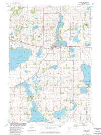
1982 Map of Dassel
USGS Topo · Published 1982About this map
The town of Dassel serves as the central hub of this Meeker County landscape, where the Burlington Northern railroad corridor dictates the east-west orientation of local development. This 1980s-era topographic study reveals a terrain heavily defined by its glacial history, featuring a dense concentration of water bodies including the expansive Lake Washington and Collinwood Lake. The rural character of the surrounding townships is anchored by community landmarks such as the Pioneer Country Ch and the Steelsville Cem, which offer significant value for genealogists and local historians tracing family roots in central Minnesota.
Find a feature on this map
35 named features on this map. Tap any name to fly to it.
Don’t see what you’re looking for? This feature index may not catch every label — zoom into the map to look around manually.
Map Details
Editions of this 1982 Dassel Map
This is the sole edition of this map. No revisions or reprints were ever made.
Other maps of this area

1953 · New Ulm
USGS Topo · 1:250,000

1953 · Saint Cloud
USGS Topo · 1:250,000

1957 · Saint Cloud
USGS Topo · 1:250,000

1957 · New Ulm
USGS Topo · 1:250,000

1958 · New Ulm
USGS Topo · 1:250,000

1958 · Saint Cloud
USGS Topo · 1:250,000

1958 · Glencoe
USGS Topo · 1:62,500

1958 · Dassel
USGS Topo · 1:62,500

1958 · Cokato
USGS Topo · 1:62,500

1958 · Hutchinson
USGS Topo · 1:62,500