1960s Maps of Litchfield, Minnesota
Explore 2 historic maps of Litchfield from the 1960s. These maps offer a rare glimpse into what life looked like during the 1960s — showing old roads, neighborhoods, homes, and landmarks that have changed or disappeared over time.
Whether you're researching your family's past, planning a metal detecting trip, or studying how Litchfield's landscape evolved across the 1960s, these high-resolution maps are a powerful tool for exploring the history of this region.
- Focus on a specific era: All maps on this page are from the 1960s, giving you a focused view of this time period.
- See what’s changed: Compare century-old streets, trails, and buildings to today's modern landscape using overlays and satellite layers.
- Research with precision: Use these maps for genealogy, historical research, land use analysis, or educational projects.
- View, download, or print: Maps are fully viewable online in high resolution, and can be downloaded or printed for your own records.
Start exploring Litchfield's history through authentic maps from the 1960s. This is your window into the past.
Litchfield, MN maps
(2)- 1967 Map of Litchfield South, 1968 Print
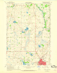
 1967 Litchfield South1968 Print · USGSMeeker County is shown in the late sixties as a thriving network of lakefront settlements and rural school districts. Genealogists and local historians can trace family locations near landmarks like Ness Ch, Beckville, and the Minnie-Belle Sch.3 unique versions available
 - 1967 Map of Litchfield North, 1968 Print
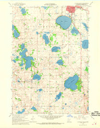
 1967 Litchfield North1968 Print · USGSMeeker County in the late sixties centers on the growing city of Litchfield and its surrounding wetlands. Genealogists and local historians can trace the town's footprint through the Great Northern rail line, Calvary Cem, and St Phillips Sch.3 unique versions available
End of results
Showing maps 1-2 of 2
Top cities near Litchfield
- Hutchinson historical maps
- Dassel historical maps
- Watkins historical maps
- Greenleaf historical maps
- Forest City historical maps
- Kimball historical maps
See more
Frequently asked questions
- What are the different types of historical maps available for Litchfield?
- What is the oldest map of Litchfield?
- Where can I purchase historical maps of Litchfield for my home or office?
- Where can I download high-res historical maps of Litchfield?
- Are there historical topographic maps available for Litchfield?
- Is there historical aerial imagery available for Litchfield?
- Where are historical maps of Litchfield sourced from?