1900s (20th Century) Maps of Little Falls, Minnesota
Explore 16 historic maps of Little Falls from the 1900s (20th Century). These maps offer a rare glimpse into what life looked like during the 1900s — showing old roads, neighborhoods, homes, and landmarks that have changed or disappeared over time.
Whether you're researching your family's past, planning a metal detecting trip, or studying how Little Falls's landscape evolved across the 1900s, these high-resolution maps are a powerful tool for exploring the history of this region.
- Focus on a specific era: All maps on this page are from the 1900s, giving you a focused view of this time period.
- See what’s changed: Compare century-old streets, trails, and buildings to today's modern landscape using overlays and satellite layers.
- Research with precision: Use these maps for genealogy, historical research, land use analysis, or educational projects.
- View, download, or print: Maps are fully viewable online in high resolution, and can be downloaded or printed for your own records.
Start exploring Little Falls's history through authentic maps from the 1900s. This is your window into the past.
Little Falls, MN maps
(16)- 1948 Map of Belle Prairie, 1961 Print
 1948 Belle Prairie1961 Print · USGSMorrison and Crow Wing counties are captured here in the late 1940s, a landscape defined by military grounds and a dense network of country schools. Researchers can trace the legacy of early settlements through Old Darling Mission Cemetery, the Northern Pacific line at Darling Switch, and St Mathias Church.
 - 1948 Map of Little Falls, 1973 Print
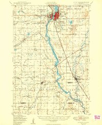
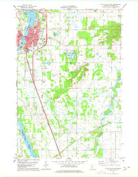
 1948 Little Falls1973 Print · USGSMid-century Central Minnesota comes alive in this survey of the river valleys and rail towns north of St. Cloud. Genealogists can locate family landmarks like St Mary Church, Pike Creek Town Hall, and numerous rural schools from Bowlus to Royalton.
 - 1950 Map of Belle Prairie
 1950 Belle Prairie1950 Print · USGSMorrison and Crow Wing counties are captured here in the late 1940s, showing a landscape defined by the winding Mississippi and sprawling military grounds. Researchers can trace rural lineages through local landmarks like St Mathias Church, Darling Switch, and Rail Prairie Town Hall.2 unique versions available
 - 1950 Map of Little Falls
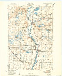
 1950 Little Falls1950 Print · USGSMid-century Morrison County reveals a landscape of river-driven industry and rural township life along the Mississippi River. Genealogists can trace family roots through numerous sites like St Stan Kostka Cemetery, School No 54, and Pike Creek Town Hall.2 unique versions available
 - 1953 Map of Brainerd, 1966 Print
 1953 Brainerd1966 Print · USGSCentral Minnesota's lake country and iron ranges are detailed in the mid-fifties, showing the intersection of industry and wilderness. Researchers can locate specific local landmarks like the Crow Wing County Courthouse or trace the early paths of the Soo Line Railroad and the Cuyuna Range Iron Mines.3 unique versions available
 - 1953 Map of Saint Cloud, 1968 Print
 1953 Saint Cloud1968 Print · USGSCentral Minnesota's lake country and the Mississippi River valley are caught in a period of steady mid-century growth. Researchers can trace historic rail lines, old granite works, and local landmarks like St. Johns University, Camp Ripley, and the shores of Lake Minnewaska.3 unique versions available
 - 1956 Map of Belle Prairie, 1958 Print
 1956 Belle Prairie1958 Print · USGSMorrison County saw significant military and rail activity during the mid-fifties, centered on the Mississippi River corridor. You can trace the perimeter of the Camp Ripley Military Reservation and locate old rural landmarks like School No 117 and the Camp Ripley Junction Station.2 unique versions available
 - 1957 Map of Brainerd
 1957 Brainerd1957 Print · USGSNorth-central Minnesota's lake-rich landscape is captured in the mid-1950s as a crossroads of rail, river, and forest. Genealogists and historians can trace the paths of the Great Northern and Soo Line railroads through hubs like Brainerd, Wadena, and Detroit Lakes.
 - 1957 Map of Saint Cloud
 1957 Saint Cloud1957 Print · USGSCentral Minnesota's lake country and rail corridors are meticulously detailed in the mid-1950s. Genealogists and researchers can trace the growth of towns like Alexandria, Willmar, and Saint Cloud along the Great Northern railroad line.
 - 1958 Map of Saint Cloud
 1958 Saint Cloud1958 Print · USGSCentral Minnesota in the mid-1950s shows a landscape of growing regional hubs and hundreds of glacial lakes connected by an extensive rail network. Genealogists and historians can trace the early footprints of Saint Cloud, Alexandria, and Willmar along the Great Northern Railway.
 - 1958 Map of Brainerd
 1958 Brainerd1958 Print · USGSCentral Minnesota in the late fifties is a landscape of dense lake chains, rail hubs, and sprawling state forests. Genealogists and local historians can trace old property alignments near the Mississippi River or locate family sites in Brainerd, Little Falls, and Detroit Lakes.
 - 1965 Map of Brainerd
 1965 Brainerd1965 Print · USGSNorth-central Minnesota in the mid-fifties presents a complex landscape of sprawling lake systems and established rail corridors. Genealogists and historians can trace the growth of timber towns along the Northern Pacific RR and explore early borders of the White Earth Indian Reservation or Tamarac National Wildlife Refuge.
 - 1978 Map of Little Falls West
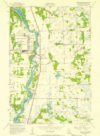
 1978 Little Falls West1978 Print · USGSThe western reaches of Little Falls and the surrounding Morrison County countryside are captured here in the late seventies. Genealogists and local historians can locate Our Lady of Lourdes Cem, the village of Sobieski, and the riverfront at Charles A Lindbergh State Park.2 unique versions available
 - 1978 Map of Little Falls East
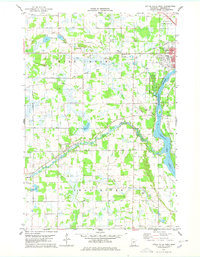
 1978 Little Falls East1978 Print · USGSLittle Falls and the surrounding Morrison County prairies are captured here in the late seventies. Genealogists can locate several local burial grounds like Oakland Cem and St Marys Cem, or trace the tracks of the Soo Line and Burlington Northern railroads.2 unique versions available
 - 1986 Map of St. Cloud
 1986 St. Cloud1986 Print · USGSCentral Minnesota in the mid-1980s reveals a landscape where river industry and growing highway corridors meet traditional farming communities. Researchers can trace the layout of small-town landmarks like St Wendel Ch and St Anna Cem or follow the path of the Sauk River as it winds toward the Mississippi.2 unique versions available
 - 1986 Map of Brainerd
 1986 Brainerd1986 Print · USGSCentral Minnesota's lake country and river junctions are captured here in the mid-1980s. Genealogists and historians can trace the Burlington Northern line through Staples or locate family sites near Brainerd State Hospital and Gull Lake.2 unique versions available
End of results
Showing maps 1-16 of 16
Top cities near Little Falls
- Rice historical maps
- Belle Prairie historical maps
- Royalton historical maps
- Cushing historical maps
- Randall historical maps
- Upsala historical maps
See more
Top neighborhoods of Little Falls
- Maple Leaf Court historical maps
- Suburban Mobile Home Park historical maps
- Belle Prairie historical maps
Frequently asked questions
- What are the different types of historical maps available for Little Falls?
- What is the oldest map of Little Falls?
- Where can I purchase historical maps of Little Falls for my home or office?
- Where can I download high-res historical maps of Little Falls?
- Are there historical topographic maps available for Little Falls?
- Is there historical aerial imagery available for Little Falls?
- Where are historical maps of Little Falls sourced from?