1910s Maps of Dunvilla, Minnesota
Explore 2 historic maps of Dunvilla from the 1910s. These maps offer a rare glimpse into what life looked like during the 1910s — showing old roads, neighborhoods, homes, and landmarks that have changed or disappeared over time.
Whether you're researching your family's past, planning a metal detecting trip, or studying how Dunvilla's landscape evolved across the 1910s, these high-resolution maps are a powerful tool for exploring the history of this region.
- Focus on a specific era: All maps on this page are from the 1910s, giving you a focused view of this time period.
- See what’s changed: Compare century-old streets, trails, and buildings to today's modern landscape using overlays and satellite layers.
- Research with precision: Use these maps for genealogy, historical research, land use analysis, or educational projects.
- View, download, or print: Maps are fully viewable online in high resolution, and can be downloaded or printed for your own records.
Start exploring Dunvilla's history through authentic maps from the 1910s. This is your window into the past.
Dunvilla, MN maps
(2)- 1914 Map of Pelican Rapids, 1949 Print
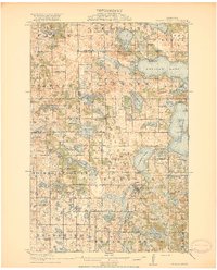
 1914 Pelican Rapids1949 Print · USGSThe glacier-carved landscape of Otter Tail County is shown here just before the First World War, when rural schools and lakefront resorts defined the local character. Genealogists can trace family roots through sites like South Emmanuel Church and Bangor Cemetery or locate the many schoolhouses including Rollag School.
 - 1917 Map of Pelican Rapids
 1917 Pelican Rapids1917 Print · USGSOtter Tail County was a landscape of dense rural school districts and lakeside retreats just before the First World War. Genealogists can trace family footprints through dozens of landmarks like Swede Grove Church, Dunn's Resort, and Bangor Cemetery.3 unique versions available
End of results
Showing maps 1-2 of 2
Top cities near Dunvilla
- Detroit Lakes historical maps
- Pelican Rapids historical maps
- Lake Eunice historical maps
- Cormorant historical maps
- Lake Park historical maps
- Audubon historical maps
See more
Frequently asked questions
- What are the different types of historical maps available for Dunvilla?
- What is the oldest map of Dunvilla?
- Where can I purchase historical maps of Dunvilla for my home or office?
- Where can I download high-res historical maps of Dunvilla?
- Are there historical topographic maps available for Dunvilla?
- Is there historical aerial imagery available for Dunvilla?
- Where are historical maps of Dunvilla sourced from?