1970s Maps of Eagle Lake Township, Minnesota
Explore 2 historic maps of Eagle Lake Township from the 1970s. These maps offer a rare glimpse into what life looked like during the 1970s — showing old roads, neighborhoods, homes, and landmarks that have changed or disappeared over time.
Whether you're researching your family's past, planning a metal detecting trip, or studying how Eagle Lake Township's landscape evolved across the 1970s, these high-resolution maps are a powerful tool for exploring the history of this region.
- Focus on a specific era: All maps on this page are from the 1970s, giving you a focused view of this time period.
- See what’s changed: Compare century-old streets, trails, and buildings to today's modern landscape using overlays and satellite layers.
- Research with precision: Use these maps for genealogy, historical research, land use analysis, or educational projects.
- View, download, or print: Maps are fully viewable online in high resolution, and can be downloaded or printed for your own records.
Start exploring Eagle Lake Township's history through authentic maps from the 1970s. This is your window into the past.
Eagle Lake Township, MN maps
(2)- 1973 Map of Stalker Lake, 1975 Print
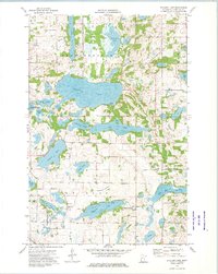 1973 Stalker Lake1975 Print · USGSOtter Tail County’s lake-studded landscape is captured here in the early 1970s, showcasing the rural character of Tordenskjold and Eagle Lake. Genealogists and local historians can trace family-named sites and community centers like St Olaf Cem, Tordenskjold Ch, and the central Townhall.
 - 1973 Map of Ashby, 1975 Print
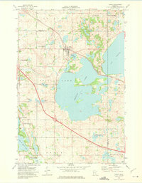 1973 Ashby1975 Print · USGSThe lake-strewn country of West Central Minnesota is captured here in the early 1970s, focused on the town of Ashby. Researchers can trace the Burlington Northern line and locate local landmarks like the Pelican Lake Cem and Erdahl Cem.
End of results
Showing maps 1-2 of 2
Top cities near Eagle Lake Township
- Battle Lake historical maps
- Evansville historical maps
- Ashby historical maps
- Brandon historical maps
- Barrett historical maps
- Underwood historical maps
See more
Frequently asked questions
- What are the different types of historical maps available for Eagle Lake Township?
- What is the oldest map of Eagle Lake Township?
- Where can I purchase historical maps of Eagle Lake Township for my home or office?
- Where can I download high-res historical maps of Eagle Lake Township?
- Are there historical topographic maps available for Eagle Lake Township?
- Is there historical aerial imagery available for Eagle Lake Township?
- Where are historical maps of Eagle Lake Township sourced from?