1960s Maps of Hinckley Township, Minnesota
Explore 5 historic maps of Hinckley Township from the 1960s. These maps offer a rare glimpse into what life looked like during the 1960s — showing old roads, neighborhoods, homes, and landmarks that have changed or disappeared over time.
Whether you're researching your family's past, planning a metal detecting trip, or studying how Hinckley Township's landscape evolved across the 1960s, these high-resolution maps are a powerful tool for exploring the history of this region.
- Focus on a specific era: All maps on this page are from the 1960s, giving you a focused view of this time period.
- See what’s changed: Compare century-old streets, trails, and buildings to today's modern landscape using overlays and satellite layers.
- Research with precision: Use these maps for genealogy, historical research, land use analysis, or educational projects.
- View, download, or print: Maps are fully viewable online in high resolution, and can be downloaded or printed for your own records.
Start exploring Hinckley Township's history through authentic maps from the 1960s. This is your window into the past.
Hinckley Township, MN maps
(5)- 1961 Map of Sandstone, 1963 Print
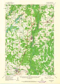 1961 Sandstone1963 Print · USGSPine County in the early sixties centers on the river-and-rail corridor through Sandstone and Hinckley. Researchers can trace rural lineages through the Dell Grove Cem, Rose Hill Cem, and local schoolhouses like Cloverdale Sch.2 unique versions available
 - 1961 Map of Brook Park, 1963 Print
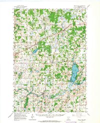 1961 Brook Park1963 Print · USGSSettlements along the Great Northern railroad thrived in the early sixties as they served this stretch of Pine and Kanabec counties. Genealogists and historians can trace family locations near the Brook Park Cem, Grasston, and the St Gerard Mission House.2 unique versions available
 - 1961 Map of Pine City, 1963 Print
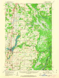 1961 Pine City1963 Print · USGSPine City and the surrounding river valleys are captured here in the early 1960s as Interstate 35 began to reshape the region. Genealogists can trace family footprints across numerous sites like the Bohemian Cem, Milburn Ch, and over ten numbered schoolhouses.2 unique versions available
 - 1965 Map of Stillwater
 1965 Stillwater1965 Print · USGSThe Twin Cities and the St. Croix Valley are mapped here during a period of significant post-war growth and industrial transit. Genealogists and historians can trace rail lines like the Northern Pacific RR through towns such as Rush City, Amery, and Balsam Lake.
 - 1968 Map of Kroschel, 1970 Print
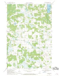 1968 Kroschel1970 Print · USGSThe Kanabec and Pine county line in the late sixties reveals a landscape of wooded wetlands and isolated farmsteads. Genealogists and researchers can locate family sites near Kroschel, St John Ch, and the Trinity Cem along the Grindstone River branches.
End of results
Showing maps 1-5 of 5
Top cities near Hinckley Township
- Pine City historical maps
- Sandstone historical maps
- Hinckley historical maps
- Askov historical maps
- Finlayson historical maps
- Kroschel historical maps
See more
Frequently asked questions
- What are the different types of historical maps available for Hinckley Township?
- What is the oldest map of Hinckley Township?
- Where can I purchase historical maps of Hinckley Township for my home or office?
- Where can I download high-res historical maps of Hinckley Township?
- Are there historical topographic maps available for Hinckley Township?
- Is there historical aerial imagery available for Hinckley Township?
- Where are historical maps of Hinckley Township sourced from?