1980s Maps of Hinckley Township, Minnesota
Explore 7 historic maps of Hinckley Township from the 1980s. These maps offer a rare glimpse into what life looked like during the 1980s — showing old roads, neighborhoods, homes, and landmarks that have changed or disappeared over time.
Whether you're researching your family's past, planning a metal detecting trip, or studying how Hinckley Township's landscape evolved across the 1980s, these high-resolution maps are a powerful tool for exploring the history of this region.
- Focus on a specific era: All maps on this page are from the 1980s, giving you a focused view of this time period.
- See what’s changed: Compare century-old streets, trails, and buildings to today's modern landscape using overlays and satellite layers.
- Research with precision: Use these maps for genealogy, historical research, land use analysis, or educational projects.
- View, download, or print: Maps are fully viewable online in high resolution, and can be downloaded or printed for your own records.
Start exploring Hinckley Township's history through authentic maps from the 1980s. This is your window into the past.
Hinckley Township, MN maps
(7)- 1980 Map of Sandstone
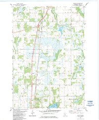
 1980 Sandstone1980 Print · USGSPine County and the Minnesota-Wisconsin borderlands are shown here in the early eighties as a region of dense state forests and river corridors. Genealogists and historians can trace rail-town development along the Burlington Northern including Sandstone, Askov, and Hinckley.
 - 1982 Map of Hinckley
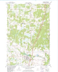 1982 Hinckley1982 Print · USGSPine County's rail and river landscape is captured here in the early eighties as the modern highway system bypasses traditional settlements. Genealogists and local historians can trace family sites at Emmanuel Ch, Evergreen Memorial Park, and the State Fish Hatchery.
 - 1983 Map of Beroun, 1984 Print
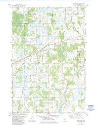
 1983 Beroun1984 Print · USGSPine County in the early eighties is mapped here as a network of rail-side settlements and winding marshlands. Genealogists and local historians can trace family locations near St Joseph Cem, the village of Beroun, and the Poke station.2 unique versions available
 - 1983 Map of Brook Park, 1984 Print
 1983 Brook Park1984 Print · USGSIn the early 1980s, this portion of Pine and Kanabec counties highlights a landscape defined by the Burlington Northern rail line. Genealogists can locate the Brook Park Cem and trace the winding paths of Pokegama Creek and Mission Creek.
 - 1985 Map of Grantsburg
 1985 Grantsburg1985 Print · USGSThe river borderlands of Minnesota and Wisconsin come alive in the mid-1980s, showcasing the intricate water networks and forest preserves of Burnett and Pine counties. Trace the rail lines of the Soo Line or find rural landmarks like Trade Lake Ch and Hildas Corner.2 unique versions available
 - 1985 Map of Mora
 1985 Mora1985 Print · USGSCentral Minnesota's river valleys and farming hubs are captured here in the mid-eighties, showing the region before significant modern expansion. Researchers can trace historic rail lines like the Burlington Northern and locate community landmarks in Mora, Milaca, and Princeton.
 - 1985 Map of Mille Lacs Lake
 1985 Mille Lacs Lake1985 Print · USGSMille Lacs Lake and its surrounding settlements are shown in the mid-1980s as a hub of lake-shore recreation and rail commerce. Researchers can trace historic transport lines like the Soo Line and locate communities such as Wahkon and Garrison.2 unique versions available
End of results
Showing maps 1-7 of 7
Top cities near Hinckley Township
- Pine City historical maps
- Sandstone historical maps
- Hinckley historical maps
- Askov historical maps
- Finlayson historical maps
- Kroschel historical maps
See more
Frequently asked questions
- What are the different types of historical maps available for Hinckley Township?
- What is the oldest map of Hinckley Township?
- Where can I purchase historical maps of Hinckley Township for my home or office?
- Where can I download high-res historical maps of Hinckley Township?
- Are there historical topographic maps available for Hinckley Township?
- Is there historical aerial imagery available for Hinckley Township?
- Where are historical maps of Hinckley Township sourced from?