1960s Maps of Norman Township, Minnesota
Explore 4 historic maps of Norman Township from the 1960s. These maps offer a rare glimpse into what life looked like during the 1960s — showing old roads, neighborhoods, homes, and landmarks that have changed or disappeared over time.
Whether you're researching your family's past, planning a metal detecting trip, or studying how Norman Township's landscape evolved across the 1960s, these high-resolution maps are a powerful tool for exploring the history of this region.
- Focus on a specific era: All maps on this page are from the 1960s, giving you a focused view of this time period.
- See what’s changed: Compare century-old streets, trails, and buildings to today's modern landscape using overlays and satellite layers.
- Research with precision: Use these maps for genealogy, historical research, land use analysis, or educational projects.
- View, download, or print: Maps are fully viewable online in high resolution, and can be downloaded or printed for your own records.
Start exploring Norman Township's history through authentic maps from the 1960s. This is your window into the past.
Norman Township, MN maps
(4)- 1961 Map of Sandstone, 1963 Print
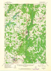 1961 Sandstone1963 Print · USGSPine County in the early sixties centers on the river-and-rail corridor through Sandstone and Hinckley. Researchers can trace rural lineages through the Dell Grove Cem, Rose Hill Cem, and local schoolhouses like Cloverdale Sch.2 unique versions available
 - 1961 Map of Moose Lake, 1963 Print
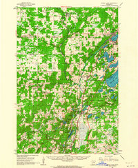 1961 Moose Lake1963 Print · USGSNortheastern Minnesota lakeside communities and the Kettle River valley are captured in the early sixties as they balanced forestry and small-town industry. Genealogists and local historians can trace family-named landmarks and rural hubs like Nordland Cem, the State Hospital, and the rail stops at Willow River and Rutledge.2 unique versions available
 - 1962 Map of Bruno, 1964 Print
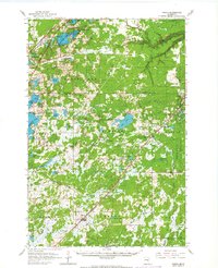 1962 Bruno1964 Print · USGSNortheastern Minnesota at the dawn of the sixties shows a network of rail-towns and timberlands centered on the Great Northern line. Genealogists and historians can trace family locations through Moose Lake Cem, Blomskog Ch, and the many small settlements like Kerrick and Duquette.2 unique versions available
 - 1962 Map of Cloverdale, 1964 Print
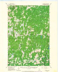 1962 Cloverdale1964 Print · USGSPine County's forested eastern reaches are captured here in the early 1960s, showing the quiet townships before modern developments. Local researchers can locate rural landmarks like the Danforth Sch, the Sand Creek Chapel, and the Great Northern rail line.2 unique versions available
End of results
Showing maps 1-4 of 4
Top cities near Norman Township
- Moose Lake historical maps
- Sandstone historical maps
- Barnum historical maps
- Willow River historical maps
- Sturgeon Lake historical maps
- Askov historical maps
See more
Frequently asked questions
- What are the different types of historical maps available for Norman Township?
- What is the oldest map of Norman Township?
- Where can I purchase historical maps of Norman Township for my home or office?
- Where can I download high-res historical maps of Norman Township?
- Are there historical topographic maps available for Norman Township?
- Is there historical aerial imagery available for Norman Township?
- Where are historical maps of Norman Township sourced from?