1980s Maps of Park Township, Minnesota
Explore 5 historic maps of Park Township from the 1980s. These maps offer a rare glimpse into what life looked like during the 1980s — showing old roads, neighborhoods, homes, and landmarks that have changed or disappeared over time.
Whether you're researching your family's past, planning a metal detecting trip, or studying how Park Township's landscape evolved across the 1980s, these high-resolution maps are a powerful tool for exploring the history of this region.
- Focus on a specific era: All maps on this page are from the 1980s, giving you a focused view of this time period.
- See what’s changed: Compare century-old streets, trails, and buildings to today's modern landscape using overlays and satellite layers.
- Research with precision: Use these maps for genealogy, historical research, land use analysis, or educational projects.
- View, download, or print: Maps are fully viewable online in high resolution, and can be downloaded or printed for your own records.
Start exploring Park Township's history through authentic maps from the 1980s. This is your window into the past.
Park Township, MN maps
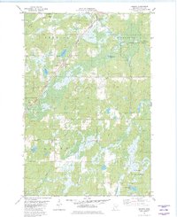
(5)- 1980 Map of Sandstone
 1980 Sandstone1980 Print · USGSPine County and the Minnesota-Wisconsin borderlands are shown here in the early eighties as a region of dense state forests and river corridors. Genealogists and historians can trace rail-town development along the Burlington Northern including Sandstone, Askov, and Hinckley.
 - 1981 Map of Kerrick, 1982 Print
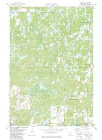
 1981 Kerrick1982 Print · USGSPine County's northern timberlands are documented in the early 1980s as the railroad still anchored local life. Researchers can trace family sites at St Michaels Cem or explore the wetlands around Kerrick and Walthausen Lake.
 - 1981 Map of Duxbury, 1982 Print
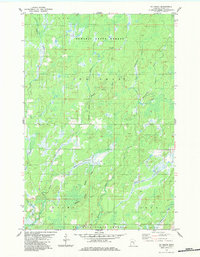
 1981 Duxbury1982 Print · USGSPine County’s wilder reaches are shown here in the early 1980s, before modern developments altered these state forest lands. Researchers can trace the rural settlement of Duxbury and find family history at Danforth Cem or the Eaglehead Lookout Tower.
 - 1983 Map of Ox Creek
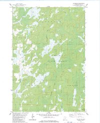
 1983 Ox Creek1983 Print · USGSPine County, Minnesota, remains a deep-woods wilderness in the early 1980s where the state forests meet the Wisconsin line. Trace the path of the State Boundary Trail or follow the winding Lower Tamarack River and McDermott Creek through the townships of New Dosey and Arna.
 - 1983 Map of Holyoke SW
 1983 Holyoke SW1983 Print · USGSPine County's wilderness along the Wisconsin border is captured here in the early 1980s, showing a landscape of deep forests and winding rivers. Researchers can trace the courses of the Net River and Keene Creek through the Nemadji State Forest.
End of results
Showing maps 1-5 of 5
Top cities near Park Township
- Barnum historical maps
- Holyoke historical maps
- Dairyland historical maps
- Bruno historical maps
- Kerrick historical maps
- Duquette historical maps
See more
Frequently asked questions
- What are the different types of historical maps available for Park Township?
- What is the oldest map of Park Township?
- Where can I purchase historical maps of Park Township for my home or office?
- Where can I download high-res historical maps of Park Township?
- Are there historical topographic maps available for Park Township?
- Is there historical aerial imagery available for Park Township?
- Where are historical maps of Park Township sourced from?