1960s Maps of Farwell, Minnesota
Explore 2 historic maps of Farwell from the 1960s. These maps offer a rare glimpse into what life looked like during the 1960s — showing old roads, neighborhoods, homes, and landmarks that have changed or disappeared over time.
Whether you're researching your family's past, planning a metal detecting trip, or studying how Farwell's landscape evolved across the 1960s, these high-resolution maps are a powerful tool for exploring the history of this region.
- Focus on a specific era: All maps on this page are from the 1960s, giving you a focused view of this time period.
- See what’s changed: Compare century-old streets, trails, and buildings to today's modern landscape using overlays and satellite layers.
- Research with precision: Use these maps for genealogy, historical research, land use analysis, or educational projects.
- View, download, or print: Maps are fully viewable online in high resolution, and can be downloaded or printed for your own records.
Start exploring Farwell's history through authentic maps from the 1960s. This is your window into the past.
Farwell, MN maps
(2)- 1966 Map of Farwell, 1967 Print
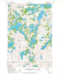 1966 Farwell1967 Print · USGSThe glacial lake country of Douglas and Pope Counties comes to life in the mid-1960s, showing a landscape of small farmsteads and rural parishes. Genealogists can trace family roots through numerous sites like St Pauls Ch Cem, Holmes City, and the Park Region Sch.
 - 1968 Map of Lowry, 1970 Print
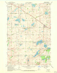 1968 Lowry1970 Print · USGSPope County’s prairie and lake country is captured here in the late sixties as agricultural life revolved around the Soo Line railroad. Genealogists and local historians can locate rural landmarks like Indherred Ch Cem, Ben Wade Cem, and Norunga Ch.
End of results
Showing maps 1-2 of 2
Top cities near Farwell
- Alexandria historical maps
- Glenwood historical maps
- Starbuck historical maps
- Holmes City historical maps
- Hoffman historical maps
- Brandon historical maps
See more
Frequently asked questions
- What are the different types of historical maps available for Farwell?
- What is the oldest map of Farwell?
- Where can I purchase historical maps of Farwell for my home or office?
- Where can I download high-res historical maps of Farwell?
- Are there historical topographic maps available for Farwell?
- Is there historical aerial imagery available for Farwell?
- Where are historical maps of Farwell sourced from?