1990s Maps of Redwood County, Minnesota
Explore 3 historic maps of Redwood County from the 1990s. These maps offer a rare glimpse into what life looked like during the 1990s — showing old roads, neighborhoods, homes, and landmarks that have changed or disappeared over time.
Whether you're researching your family's past, planning a metal detecting trip, or studying how Redwood County's landscape evolved across the 1990s, these high-resolution maps are a powerful tool for exploring the history of this region.
- Focus on a specific era: All maps on this page are from the 1990s, giving you a focused view of this time period.
- See what’s changed: Compare century-old streets, trails, and buildings to today's modern landscape using overlays and satellite layers.
- Research with precision: Use these maps for genealogy, historical research, land use analysis, or educational projects.
- View, download, or print: Maps are fully viewable online in high resolution, and can be downloaded or printed for your own records.
Start exploring Redwood County's history through authentic maps from the 1990s. This is your window into the past.
Redwood County, MN maps
(3)- 1991 Map of New Ulm
 1991 New Ulm1991 Print · USGSThe Minnesota River valley serves as the backbone for this late-century look at the agricultural heartland between New Ulm and Mankato. Researchers can trace the layout of traditional prairie towns like Sleepy Eye and Madelia or explore recreation sites at Fort Ridgely State Park.
 - 1992 Map of Redwood Falls, 1995 Print
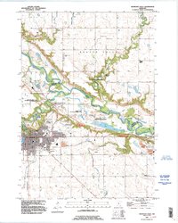 1992 Redwood Falls1995 Print · USGSRedwood Falls and the winding Minnesota River valley are captured here in the early nineties during a period of steady growth. Genealogists can locate family sites at St Catherine Cem or Beaver Falls Cem, and trace the bounds of the Lower Sioux Indian Reservation.
 - 1992 Map of Morton, 1995 Print
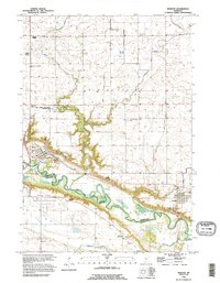 1992 Morton1995 Print · USGSThe Minnesota River valley was entering the mid-nineties as a landscape deeply marked by nineteenth-century history and agricultural engineering. Researchers can trace the Old Minnesota Indian Treaty Boundary and the grounds of the Birch Coulee Battlefield Historic Site.
End of results
Showing maps 1-3 of 3
Top cities of Redwood County
- Redwood Falls historical maps
- Morgan historical maps
- Lamberton historical maps
- Wabasso historical maps
- Walnut Grove historical maps
- Belview historical maps
See more
Frequently asked questions
- What are the different types of historical maps available for Redwood County?
- What is the oldest map of Redwood County?
- Where can I purchase historical maps of Redwood County for my home or office?
- Where can I download high-res historical maps of Redwood County?
- Are there historical topographic maps available for Redwood County?
- Is there historical aerial imagery available for Redwood County?
- Where are historical maps of Redwood County sourced from?