1960s Maps of Avon, Minnesota
Explore 3 historic maps of Avon from the 1960s. These maps offer a rare glimpse into what life looked like during the 1960s — showing old roads, neighborhoods, homes, and landmarks that have changed or disappeared over time.
Whether you're researching your family's past, planning a metal detecting trip, or studying how Avon's landscape evolved across the 1960s, these high-resolution maps are a powerful tool for exploring the history of this region.
- Focus on a specific era: All maps on this page are from the 1960s, giving you a focused view of this time period.
- See what’s changed: Compare century-old streets, trails, and buildings to today's modern landscape using overlays and satellite layers.
- Research with precision: Use these maps for genealogy, historical research, land use analysis, or educational projects.
- View, download, or print: Maps are fully viewable online in high resolution, and can be downloaded or printed for your own records.
Start exploring Avon's history through authentic maps from the 1960s. This is your window into the past.
Avon, MN maps
(3)- 1965 Map of Farming, 1966 Print
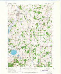
 1965 Farming1966 Print · USGSStearns County in the mid-sixties reveals a landscape of family-named glacial lakes and a vanishing network of rural schoolhouses. Researchers can trace the Great Northern tracks and locate several community centers including Farming and Immanuel Ch.2 unique versions available
 - 1965 Map of Holdingford, 1966 Print
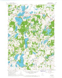
 1965 Holdingford1966 Print · USGSStearns County in the mid-1960s shows a landscape of small farming communities and a dense network of country schools. Researchers can trace the Soo Line rail corridor through Holdingford or locate rural landmarks like St Anna and Sacred Heart Mission.
 - 1965 Map of Avon, 1967 Print
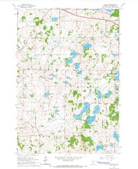
 1965 Avon1967 Print · USGSIn the mid-1960s, this lake-rich region of Stearns County shows the expansion of the St Johns University campus alongside the established town of Avon. Genealogists and local historians can trace family-named sites like Dullinger Lake and Schmid Lake or locate vanished rural landmarks such as School No 2029.3 unique versions available
End of results
Showing maps 1-3 of 3
Top cities near Avon
- St. Cloud historical maps
- Sartell historical maps
- Saint Joseph historical maps
- Cold Spring historical maps
- Rockville historical maps
- Albany historical maps
See more
Frequently asked questions
- What are the different types of historical maps available for Avon?
- What is the oldest map of Avon?
- Where can I purchase historical maps of Avon for my home or office?
- Where can I download high-res historical maps of Avon?
- Are there historical topographic maps available for Avon?
- Is there historical aerial imagery available for Avon?
- Where are historical maps of Avon sourced from?