
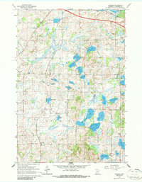
1965 Map of Farming
USGS Topo · Published 1966About this map
Glacial lakes and small-town infrastructure characterize this mid-1960s study of central Minnesota. The small community of Farming serves as a local hub near the southern edge, while the Great Northern rail line cuts across the northern corner, connecting the area to broader trade networks. The landscape is heavily dotted with water bodies named for local families, including Schwinghamer Lake, Eggert Lake, and Backes Lake, interspersed with numerous gravel pits that hint at the region's extractive activity.
Find a feature on this map
38 named features on this map. Tap any name to fly to it.
Don’t see what you’re looking for? This feature index may not catch every label — zoom into the map to look around manually.
Map Details
Editions of this 1965 Farming Map
2 editions found
Other maps of this area

1953 · Saint Cloud
USGS Topo · 1:250,000

1957 · Saint Cloud
USGS Topo · 1:250,000

1958 · Saint Cloud
USGS Topo · 1:250,000

1965 · Albany
USGS Topo · 1:24,000

1965 · Holdingford
USGS Topo · 1:24,000

1965 · Freeport
USGS Topo · 1:24,000

1965 · St Martin
USGS Topo · 1:24,000

1965 · Avon
USGS Topo · 1:24,000

1967 · Cold Spring
USGS Topo · 1:24,000

1967 · Paynesville
USGS Topo · 1:24,000