
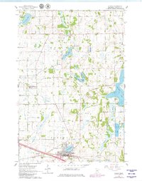
1965 Map of Albany
USGS Topo · Published 1966About this map
Albany sits at the southern edge of this mid-1960s landscape, positioned along the Great Northern rail line and the shores of Albany Lake. The surrounding Stearns County countryside is characterized by a high density of small glacial lakes and an extensive network of drainage infrastructure, such as County Ditch No 28 and County Ditch No 18, which shaped the local agricultural potential. To the north, the small settlement of St. Anthony serves as a secondary focal point in a region dotted with numbered rural schoolhouses, including School No 2081 and School No 2021. Family history researchers will find several well-documented burial grounds, such as St Johns Cem, Seven Dolors Cem, and Ebenezer Cem. The map captures the transition between the rolling prairie and the numerous water bodies like Two River Lake and Bear Lake that define this part of central Minnesota.
Find a feature on this map
32 named features on this map. Tap any name to fly to it.
Don’t see what you’re looking for? This feature index may not catch every label — zoom into the map to look around manually.
Map Details
Editions of this 1965 Albany Map
2 editions found
Other maps of this area

1948 · Little Falls
USGS Topo · 1:62,500

1950 · Swanville
USGS Topo · 1:62,500

1950 · Little Falls
USGS Topo · 1:62,500

1953 · Saint Cloud
USGS Topo · 1:250,000

1957 · Saint Cloud
USGS Topo · 1:250,000

1958 · Saint Cloud
USGS Topo · 1:250,000

1965 · Farming
USGS Topo · 1:24,000

1965 · Holdingford
USGS Topo · 1:24,000

1965 · Freeport
USGS Topo · 1:24,000

1965 · St Martin
USGS Topo · 1:24,000
Featured Places
- Albany, MN
- St. Anthony, MN
- Shamrock Mobile Home Park, Albany
- Saint Anthony, St. Anthony
- Stearns County, MN