
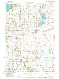
1967 Map of Paynesville
USGS Topo · Published 1968About this map
The Crow River North Fork and Sauk River define the drainage of this Stearns County landscape, where the town of Paynesville serves as a local hub. In the late 1960s, the area remained a busy junction of rail and road, with the Soo Line and Great Northern railroads crossing the terrain near numerous small-scale industrial Gravel Pits. This era shows a community in transition, maintaining rural fixtures like School No 1948 and Salem Ch while developing modern infrastructure such as the Paynesville Airport and Sewage Disposal Ponds. The eastern portion of the map is dominated by the marshy fringes of Eden Lake and Rice Lake, while the central township of Zion contains a significant National Wildlife Management Area. For genealogists, the map preserves specific local landmarks including Zion Cem and several numbered schoolhouses that served the surrounding agricultural sections.
Find a feature on this map
27 named features on this map. Tap any name to fly to it.
Don’t see what you’re looking for? This feature index may not catch every label — zoom into the map to look around manually.
Map Details
Editions of this 1967 Paynesville Map
This is the sole edition of this map. No revisions or reprints were ever made.
Other maps of this area

1953 · Saint Cloud
USGS Topo · 1:250,000

1957 · Saint Cloud
USGS Topo · 1:250,000

1958 · Saint Cloud
USGS Topo · 1:250,000

1965 · Farming
USGS Topo · 1:24,000

1965 · Greenwald
USGS Topo · 1:24,000

1965 · St Martin
USGS Topo · 1:24,000

1967 · Lake Koronis
USGS Topo · 1:24,000

1967 · Richmond
USGS Topo · 1:24,000

1967 · Hawick
USGS Topo · 1:24,000
1967 · Eden Valley
USGS Topo · 1:24,000