
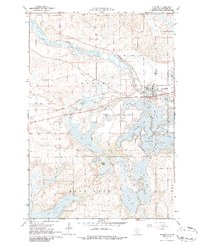
1967 Map of Richmond
USGS Topo · Published 1968About this map
The Sauk River winds across the northern half of this Stearns County landscape, creating a fertile valley dominated by the settlement of Richmond and its connection to the Great Northern rail line. This mid-1960s survey captures a geography defined by its complex glacial lake systems, including the expansive Horseshoe Lake and its numerous connected basins like Cedar Island Lake, Krons Bay, and East Lake.
Find a feature on this map
34 named features on this map. Tap any name to fly to it.
Don’t see what you’re looking for? This feature index may not catch every label — zoom into the map to look around manually.
Map Details
Editions of this 1967 Richmond Map
2 editions found
Other maps of this area

1953 · Saint Cloud
USGS Topo · 1:250,000

1957 · Saint Cloud
USGS Topo · 1:250,000

1958 · Saint Cloud
USGS Topo · 1:250,000

1965 · Farming
USGS Topo · 1:24,000

1965 · St Martin
USGS Topo · 1:24,000

1965 · Avon
USGS Topo · 1:24,000

1967 · Cold Spring
USGS Topo · 1:24,000

1967 · Paynesville
USGS Topo · 1:24,000

1967 · Lake Koronis
USGS Topo · 1:24,000

1967 · Watkins
USGS Topo · 1:24,000