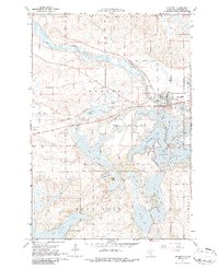
1967 Map of Richmond
USGS Topo · Published 1986About this map
The Sauk River winds through this central Minnesota landscape, defining a region where glacial topography has created an intricate network of interconnected waterways. Near the settlement of Richmond, the river transitions into a dense cluster of lakes including Horseshoe Lake, Cedar Island Lake, and the expansive Rice Lake to the south. This area is characterized by its heavy concentration of water bodies, many of which carry local family or descriptive names like Schroeder Lake, Meyers Lake, and Becker Lake.
Find a feature on this map
34 named features on this map. Tap any name to fly to it.
Don’t see what you’re looking for? This feature index may not catch every label — zoom into the map to look around manually.
Map Details
Editions of this 1967 Richmond Map
2 editions found
Other maps of this area

1953 · Saint Cloud
USGS Topo · 1:250,000

1957 · Saint Cloud
USGS Topo · 1:250,000

1958 · Saint Cloud
USGS Topo · 1:250,000

1965 · Farming
USGS Topo · 1:24,000

1965 · St Martin
USGS Topo · 1:24,000

1965 · Avon
USGS Topo · 1:24,000

1967 · Cold Spring
USGS Topo · 1:24,000

1967 · Paynesville
USGS Topo · 1:24,000

1967 · Lake Koronis
USGS Topo · 1:24,000

1967 · Richmond
USGS Topo · 1:24,000