
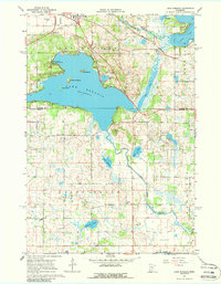
1967 Map of Lake Koronis
USGS Topo · Published 1968About this map
Lake Koronis and its distinct island chain dominate this 1960s landscape, illustrating the resort and agricultural character of the Stearns and Meeker county line. Near the northern shore, Paynesville serves as the regional hub, flanked by the Paynesville Airport and the Soo Line railroad. The map reflects a well-developed rural community, evidenced by numerous numbered schoolhouses like School No 2044 and School No 1089 scattered through the townships of Union Grove and Eden Lake.
Find a feature on this map
38 named features on this map. Tap any name to fly to it.
Don’t see what you’re looking for? This feature index may not catch every label — zoom into the map to look around manually.
Map Details
Editions of this 1967 Lake Koronis Map
2 editions found
Other maps of this area

1953 · Saint Cloud
USGS Topo · 1:250,000

1956 · Atwater
USGS Topo · 1:62,500

1957 · Saint Cloud
USGS Topo · 1:250,000

1958 · Saint Cloud
USGS Topo · 1:250,000

1967 · Grove City
USGS Topo · 1:24,000

1967 · Paynesville
USGS Topo · 1:24,000

1967 · Litchfield North
USGS Topo · 1:24,000

1967 · Richmond
USGS Topo · 1:24,000

1967 · Hawick
USGS Topo · 1:24,000
1967 · Eden Valley
USGS Topo · 1:24,000