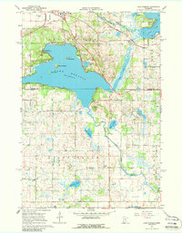
1967 Map of Lake Koronis
USGS Topo · Published 1988About this map
Lake Koronis and its distinct islands dominate this mid-century landscape on the border of Stearns and Meeker Counties. The town of Paynesville sits at the northern edge, served by the Soo Line railroad and the nearby Paynesville Airport. To the south, the terrain transitions into the township of Union Grove, a rural expanse defined by the winding course of the North Fork Crow River and a scattering of smaller water bodies like Whitney Lake and Lake Emma.
Find a feature on this map
38 named features on this map. Tap any name to fly to it.
Don’t see what you’re looking for? This feature index may not catch every label — zoom into the map to look around manually.
Map Details
Editions of this 1967 Lake Koronis Map
2 editions found
Other maps of this area

1953 · Saint Cloud
USGS Topo · 1:250,000

1956 · Atwater
USGS Topo · 1:62,500

1957 · Saint Cloud
USGS Topo · 1:250,000

1958 · Saint Cloud
USGS Topo · 1:250,000

1967 · Grove City
USGS Topo · 1:24,000

1967 · Paynesville
USGS Topo · 1:24,000

1967 · Litchfield North
USGS Topo · 1:24,000

1967 · Lake Koronis
USGS Topo · 1:24,000

1967 · Richmond
USGS Topo · 1:24,000

1967 · Hawick
USGS Topo · 1:24,000