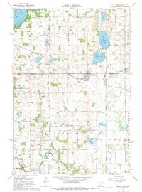
1967 Map of Eden Valley
USGS Topo · Published 1969About this map
Eden Valley sits at the junction of the Stearns Co Meeker Co line, serving as a focal point for the surrounding agricultural townships of Eden Lake, Manannah, Tyrone, and Forest Prairie. The settlement pattern is defined by the Soo Line railroad and a landscape densely pocketed with glacial features, including Rice Lake, Eden Lake, and Vails Lake. To the south, the North Fork Crow River meanders near the small community of Manannah, where the river’s course and several Gravel Pits indicate the local industrial and natural geography. This mid-century survey captures a wealth of local genealogy markers, from the Rice Lake Sch and Tyrone Sch to a high concentration of burial grounds such as Old Eden Lake Cem, Assumption Cem, and St Peters Cem, many of which remain vital links to the area’s pioneer-era Catholic and Lutheran heritage.
Find a feature on this map
30 named features on this map. Tap any name to fly to it.
Don’t see what you’re looking for? This feature index may not catch every label — zoom into the map to look around manually.
Map Details
Editions of this 1967 Eden Valley Map
This is the sole edition of this map. No revisions or reprints were ever made.
Other maps of this area

1953 · Saint Cloud
USGS Topo · 1:250,000

1957 · Saint Cloud
USGS Topo · 1:250,000

1958 · Saint Cloud
USGS Topo · 1:250,000

1958 · Dassel
USGS Topo · 1:62,500

1967 · Cold Spring
USGS Topo · 1:24,000

1967 · Grove City
USGS Topo · 1:24,000

1967 · Paynesville
USGS Topo · 1:24,000

1967 · Litchfield North
USGS Topo · 1:24,000

1967 · Lake Koronis
USGS Topo · 1:24,000

1967 · Richmond
USGS Topo · 1:24,000