1960s Maps of Maine Prairie Township, Minnesota
Explore 4 historic maps of Maine Prairie Township from the 1960s. These maps offer a rare glimpse into what life looked like during the 1960s — showing old roads, neighborhoods, homes, and landmarks that have changed or disappeared over time.
Whether you're researching your family's past, planning a metal detecting trip, or studying how Maine Prairie Township's landscape evolved across the 1960s, these high-resolution maps are a powerful tool for exploring the history of this region.
- Focus on a specific era: All maps on this page are from the 1960s, giving you a focused view of this time period.
- See what’s changed: Compare century-old streets, trails, and buildings to today's modern landscape using overlays and satellite layers.
- Research with precision: Use these maps for genealogy, historical research, land use analysis, or educational projects.
- View, download, or print: Maps are fully viewable online in high resolution, and can be downloaded or printed for your own records.
Start exploring Maine Prairie Township's history through authentic maps from the 1960s. This is your window into the past.
Maine Prairie Township, MN maps
(4)- 1967 Map of Cold Spring, 1963 Print
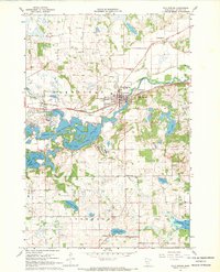 1967 Cold Spring1963 Print · USGSThe Sauk River valley and its complex chain of lakes are captured here in the late sixties. Genealogists and local researchers can trace family landmarks like St Boniface Cem, Assumption Chapel, and the rural School No 1926 near St Nicholas.2 unique versions available
 - 1967 Map of Watkins, 1968 Print
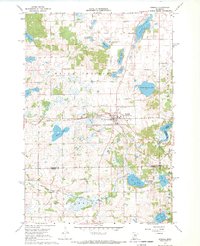
 1967 Watkins1968 Print · USGSWatkins and the surrounding central Minnesota prairies are captured here in the late sixties, showing the vital link provided by the Soo Line railroad. Genealogists and local historians can trace rural education at School No 1140 or locate the shoreline of Clear Lake and Island Lake.
 - 1967 Map of Rockville, 1969 Print
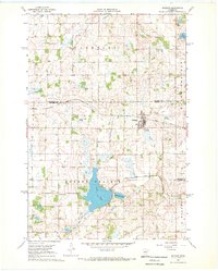
 1967 Rockville1969 Print · USGSStearns County near the Sauk River in the late sixties reveals a landscape of granite quarrying and quiet lakeside settlements. Genealogists and local historians can trace the rural layout of Marty, the Maine Prairie Cemetery, and several old quarries.
 - 1967 Map of Kimball, 1969 Print
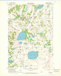
 1967 Kimball1969 Print · USGSThe village of Kimball and the surrounding prairie lakes are captured here in the late sixties as the region balanced agriculture with growing recreation. Researchers can trace the Soo Line corridor and locate local landmarks like the Drive-in Theater and St Annes Cem.2 unique versions available
End of results
Showing maps 1-4 of 4
Top cities near Maine Prairie Township
- St. Cloud historical maps
- Saint Cloud historical maps
- Sauk Rapids historical maps
- Waite Park historical maps
- Litchfield historical maps
- Saint Joseph historical maps
See more
Top neighborhoods of Maine Prairie Township
Frequently asked questions
- What are the different types of historical maps available for Maine Prairie Township?
- What is the oldest map of Maine Prairie Township?
- Where can I purchase historical maps of Maine Prairie Township for my home or office?
- Where can I download high-res historical maps of Maine Prairie Township?
- Are there historical topographic maps available for Maine Prairie Township?
- Is there historical aerial imagery available for Maine Prairie Township?
- Where are historical maps of Maine Prairie Township sourced from?