1990s Maps of Steele County, Minnesota
Explore 2 historic maps of Steele County from the 1990s. These maps offer a rare glimpse into what life looked like during the 1990s — showing old roads, neighborhoods, homes, and landmarks that have changed or disappeared over time.
Whether you're researching your family's past, planning a metal detecting trip, or studying how Steele County's landscape evolved across the 1990s, these high-resolution maps are a powerful tool for exploring the history of this region.
- Focus on a specific era: All maps on this page are from the 1990s, giving you a focused view of this time period.
- See what’s changed: Compare century-old streets, trails, and buildings to today's modern landscape using overlays and satellite layers.
- Research with precision: Use these maps for genealogy, historical research, land use analysis, or educational projects.
- View, download, or print: Maps are fully viewable online in high resolution, and can be downloaded or printed for your own records.
Start exploring Steele County's history through authentic maps from the 1990s. This is your window into the past.
Steele County, MN maps
(2)- 1991 Map of Saco, 1995 Print
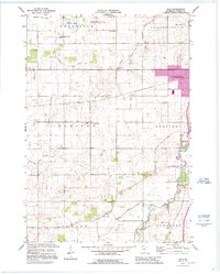 1991 Saco1995 Print · USGSSteel County farmland in the early nineties reveals a transition from traditional rural townships to modern regional centers. Genealogists can locate family burial sites at Bohemian Cem and Crane Creek Cem or trace vanished district schools like School No 2116.
 - 1992 Map of Meriden, 1995 Print
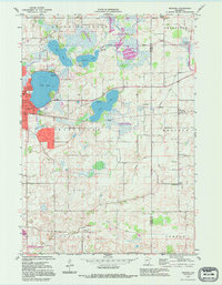 1992 Meriden1995 Print · USGSThe borderlands of Waseca and Steele Counties come to life in this late-century record of a lake-studded agricultural landscape. Genealogists can trace family roots through markers like Woodville Cem, St Paul Ch, and the rural School No 2098.
End of results
Showing maps 1-2 of 2
Top cities of Steele County
- Owatonna historical maps
- Blooming Prairie historical maps
- Medford historical maps
- Deerfield historical maps
- Ellendale historical maps
- Meriden historical maps
See more
Frequently asked questions
- What are the different types of historical maps available for Steele County?
- What is the oldest map of Steele County?
- Where can I purchase historical maps of Steele County for my home or office?
- Where can I download high-res historical maps of Steele County?
- Are there historical topographic maps available for Steele County?
- Is there historical aerial imagery available for Steele County?
- Where are historical maps of Steele County sourced from?