1960s Maps of Steele County, Minnesota
Explore 16 historic maps of Steele County from the 1960s. These maps offer a rare glimpse into what life looked like during the 1960s — showing old roads, neighborhoods, homes, and landmarks that have changed or disappeared over time.
Whether you're researching your family's past, planning a metal detecting trip, or studying how Steele County's landscape evolved across the 1960s, these high-resolution maps are a powerful tool for exploring the history of this region.
- Focus on a specific era: All maps on this page are from the 1960s, giving you a focused view of this time period.
- See what’s changed: Compare century-old streets, trails, and buildings to today's modern landscape using overlays and satellite layers.
- Research with precision: Use these maps for genealogy, historical research, land use analysis, or educational projects.
- View, download, or print: Maps are fully viewable online in high resolution, and can be downloaded or printed for your own records.
Start exploring Steele County's history through authentic maps from the 1960s. This is your window into the past.
Steele County, MN maps
(16)- 1962 Map of Medford East, 1963 Print
 1962 Medford East1963 Print · USGSSteel County agricultural and rail life in the early sixties is centered on the busy river corridor between Medford and Clinton Falls. Genealogists and local historians can trace family locations near Perry Sch, the Rock Sch, or cemeteries like Oak Hill Cem and Eklund Cem.
 - 1962 Map of Morristown, 1963 Print
 1962 Morristown1963 Print · USGSRice and Waseca counties in the early sixties reveal a landscape of river-town commerce and rural parish life. Researchers can trace family roots at Riverside Cemetery, locate the Chicago Great Western rail line, or find the Blooming Grove Church.2 unique versions available
 - 1962 Map of Owatonna, 1964 Print
 1962 Owatonna1964 Print · USGSOwatonna and the surrounding Steele County townships thrive as a major rail and educational crossroads in the early sixties. Genealogists and local historians can locate numerous rural schoolhouses and family cemeteries, including Bohemian Cemetery, Pillsbury College, and the small community of Havana.
 - 1962 Map of Moland, 1964 Print
 1962 Moland1964 Print · USGSSteele and Rice counties are captured in the early sixties, showing a landscape of established farmsteads and rural social hubs. Genealogists can locate Richland Center, the Merton Cem, and the community surrounding Moland Ch.2 unique versions available
 - 1962 Map of Owatonna SE, 1964 Print
 1962 Owatonna SE1964 Print · USGSSteele and Dodge counties in the early sixties reveal a landscape of settled townships and agricultural progress. Genealogists can trace family footprints at Oasis Cem, St Johns Sch, and the rail-side community of Claremont.
 - 1962 Map of Saco, 1964 Print
 1962 Saco1964 Print · USGSSteele County at the dawn of the 1960s shows a landscape of productive farm townships and a burgeoning transportation network near Owatonna. Researchers can trace the path of the Chicago and North Western railroad or locate local landmarks like Saco, Crane Creek Sch, and the Bohemian Cem.
 - 1962 Map of Meriden, 1964 Print
 1962 Meriden1964 Print · USGSWaseca and the surrounding farm townships are seen here in the early sixties, centered on the lakes and rail lines of south-central Minnesota. Genealogists can locate family landmarks like St Paul Ch, Karsten Cem, and rural schoolhouses such as School No 2142.
 - 1962 Map of Medford West, 1964 Print
 1962 Medford West1964 Print · USGSSteele and Rice Counties are captured here in the early sixties, showing the agricultural transformation of the southern Minnesota prairie. Researchers can trace the legacy of rural education and faith through sites like Sammon Sch, Trinity Cem, and the vanished Pelican Lake Bed.
 - 1967 Map of Steele Center, 1968 Print
 1967 Steele Center1968 Print · USGSMinnesota dairy and farm country is captured here in the late sixties, showing the rural landscape before modern expansion. Genealogists can trace family footprints near Steele Center, Holy Trinity Cem, and the Danish Cem.
 - 1967 Map of Bixby, 1968 Print
 1967 Bixby1968 Print · USGSSteele County farmland and rail-side hamlets are documented here in the late sixties. Genealogists and historians can trace the foundations of local life at Bixby, Trinity Ch, and rural landmarks like Westfield Ch Cem.2 unique versions available
 - 1967 Map of Blooming Prairie, 1968 Print
 1967 Blooming Prairie1968 Print · USGSThe fertile farmlands surrounding Blooming Prairie were captured in the late sixties, showing the vital link between the Chicago Milwaukee St Paul and Pacific rail line and the prairie economy. Local historians can trace family-named landmarks and rural hubs like Red Oak Grove Ch and Selstad Landing Field.
 - 1967 Map of Hollandale, 1968 Print
 1967 Hollandale1968 Print · USGSThe Freeborn and Steele County borderlands are shown here in the late sixties, a region defined by an intensive network of agricultural drainage. Local historians can trace the paths of Mud Creek and the Chicago Rock Island and Pacific railroad through Hollandale and Maple Island.
 - 1967 Map of Hope, 1969 Print
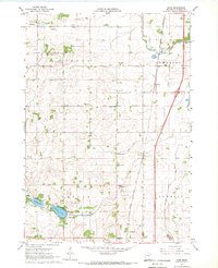 1967 Hope1969 Print · USGSSouthern Steele County in the late sixties reveals a landscape transitioning as Interstate 35 carves through traditional farmsteads. Genealogists can locate family landmarks such as the Danish Cem, Zion Ch, and several numbered schools near Hope.
 - 1967 Map of Hartland, 1969 Print
 1967 Hartland1969 Print · USGSFreeborn County in the late sixties shows a landscape defined by rail-dependent villages and extensive field drainage. Genealogists can locate family sites near St Aidens Cem or trace the old Chicago and North Western line through Hartland.
 - 1967 Map of Ellendale, 1969 Print
 1967 Ellendale1969 Print · USGSSouthern Minnesota farmland is captured here in the late sixties as the new interstate highway began to reshape rural life. Genealogists and local historians can trace the foundations of Ellendale, Geneva, and Clarks Grove, along with landmarks like North Freeborn Ch and Lutheran Cem.
 - 1967 Map of New Richland, 1969 Print
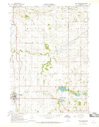 1967 New Richland1969 Print · USGSWaseca and Steele Counties appear at the end of the sixties as a meticulously drained agricultural landscape centered on the rail town of New Richland. Researchers can trace rural lineages through local landmarks like Otisco Cem, School No 2137, and the Le Sueur River Ch.
End of results
Showing maps 1-16 of 16
Top cities of Steele County
- Owatonna historical maps
- Blooming Prairie historical maps
- Medford historical maps
- Deerfield historical maps
- Ellendale historical maps
- Meriden historical maps
See more
Frequently asked questions
- What are the different types of historical maps available for Steele County?
- What is the oldest map of Steele County?
- Where can I purchase historical maps of Steele County for my home or office?
- Where can I download high-res historical maps of Steele County?
- Are there historical topographic maps available for Steele County?
- Is there historical aerial imagery available for Steele County?
- Where are historical maps of Steele County sourced from?