
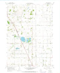
1967 Map of Bixby
USGS Topo · Published 1968About this map
Bixby sits as a quiet rail settlement along the Chicago Milwaukee St Paul and Pacific line during the late 1960s. This agricultural region of southern Minnesota is defined by a dense network of rural infrastructure, including numerous Gravel Pits and public lands such as the Aurora State Wildlife Management Area. The landscape is etched with water management features like Dodge Judicial Ditch No 1 and the Green Valley Ditch, reflecting the conversion of wetlands into productive farmland.
Find a feature on this map
26 named features on this map. Tap any name to fly to it.
Don’t see what you’re looking for? This feature index may not catch every label — zoom into the map to look around manually.
Map Details
Editions of this 1967 Bixby Map
2 editions found
Other maps of this area

1953 · Saint Paul
USGS Topo · 1:250,000

1954 · Mason City
USGS Topo · 1:250,000

1957 · Mason City
USGS Topo · 1:250,000

1958 · Mason City
USGS Topo · 1:250,000

1959 · Saint Paul
USGS Topo · 1:250,000

1962 · Owatonna
USGS Topo · 1:24,000

1962 · Owatonna SE
USGS Topo · 1:24,000

1965 · Claremont
USGS Topo · 1:24,000

1966 · Waltham
USGS Topo · 1:24,000

1966 · Hayfield NW
USGS Topo · 1:24,000