1910s Maps of Donnelly, Minnesota
Explore 3 historic maps of Donnelly from the 1910s. These maps offer a rare glimpse into what life looked like during the 1910s — showing old roads, neighborhoods, homes, and landmarks that have changed or disappeared over time.
Whether you're researching your family's past, planning a metal detecting trip, or studying how Donnelly's landscape evolved across the 1910s, these high-resolution maps are a powerful tool for exploring the history of this region.
- Focus on a specific era: All maps on this page are from the 1910s, giving you a focused view of this time period.
- See what’s changed: Compare century-old streets, trails, and buildings to today's modern landscape using overlays and satellite layers.
- Research with precision: Use these maps for genealogy, historical research, land use analysis, or educational projects.
- View, download, or print: Maps are fully viewable online in high resolution, and can be downloaded or printed for your own records.
Start exploring Donnelly's history through authentic maps from the 1910s. This is your window into the past.
Donnelly, MN maps
(3)- 1910 Map of Chokio, 1968 Print
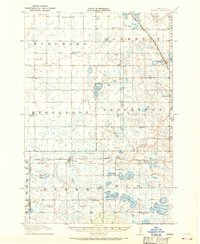 1910 Chokio1968 Print · USGSStevens County is shown here at the height of its rail-and-schoolhouse era in the early twentieth century. Genealogists can locate specific rural properties near landmarks like Harstad Slough, Town Hall, and over twenty numbered school sites including School No 35.
 - 1912 Map of Chokio
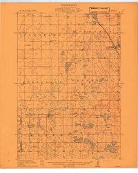 1912 Chokio1912 Print · USGSWestern Minnesota prairie life is centered on the rail lines of Donnelly and Chokio during the early twentieth century. Genealogists and researchers can trace local school districts from School No 56 to School No 42 and locate landmarks like the Town Hall and Harstad Slough.
 - 1912 Map of Morris
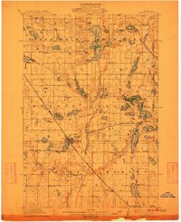 1912 Morris1912 Print · USGSThe rail hub of Morris and the surrounding Stevens County prairie are captured here at the height of the steam era. Genealogists and historians can trace dozens of early rural schoolhouses, the North Star Mill, and pioneer worship sites like Scandia Church.3 unique versions available
End of results
Showing maps 1-3 of 3
Top cities near Donnelly
- Morris historical maps
- Hancock historical maps
- Hoffman historical maps
- Chokio historical maps
- Herman historical maps
- Barrett historical maps
See more
Frequently asked questions
- What are the different types of historical maps available for Donnelly?
- What is the oldest map of Donnelly?
- Where can I purchase historical maps of Donnelly for my home or office?
- Where can I download high-res historical maps of Donnelly?
- Are there historical topographic maps available for Donnelly?
- Is there historical aerial imagery available for Donnelly?
- Where are historical maps of Donnelly sourced from?