1960s Maps of Swift County, Minnesota
Explore 14 historic maps of Swift County from the 1960s. These maps offer a rare glimpse into what life looked like during the 1960s — showing old roads, neighborhoods, homes, and landmarks that have changed or disappeared over time.
Whether you're researching your family's past, planning a metal detecting trip, or studying how Swift County's landscape evolved across the 1960s, these high-resolution maps are a powerful tool for exploring the history of this region.
- Focus on a specific era: All maps on this page are from the 1960s, giving you a focused view of this time period.
- See what’s changed: Compare century-old streets, trails, and buildings to today's modern landscape using overlays and satellite layers.
- Research with precision: Use these maps for genealogy, historical research, land use analysis, or educational projects.
- View, download, or print: Maps are fully viewable online in high resolution, and can be downloaded or printed for your own records.
Start exploring Swift County's history through authentic maps from the 1960s. This is your window into the past.
Swift County, MN maps
(14)- 1968 Map of De Graff, 1970 Print
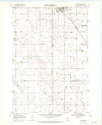
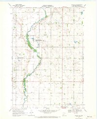
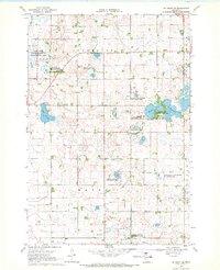
 1968 De Graff1970 Print · USGSDe Graff and the surrounding Kildare township are captured here in the late sixties, showing a landscape defined by the Great Northern rail line and prairie wetlands. Genealogists can locate St Bridget Cem, Bethesda Ch, and rural gravel pits scattered across the Chippewa River basin.
 - 1968 Map of Dry Wood Lake, 1970 Print
 1968 Dry Wood Lake1970 Print · USGSThe Stevens and Swift County borderlands are preserved here in the late sixties, a landscape defined by glacial lakes and wildlife conservation. Genealogists and researchers can trace rural community hubs like Trinity Ch Cem, St Agnes Ch, and the shores of Dry Wood Lake.
 - 1968 Map of Lake Oliver, 1970 Print
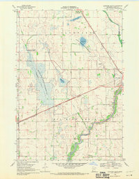
 1968 Lake Oliver1970 Print · USGSSwift and Big Stone Counties are shown here in the late sixties, a landscape defined by glacial lakes and dedicated wildlife management. Genealogists and local historians can locate Immanuel Ch, Waldrum Cem, and the old Townhall among the prairie potholes.
 - 1968 Map of Danvers, 1970 Print
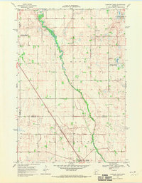
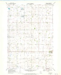 1968 Danvers1970 Print · USGSDanvers and the surrounding prairie of Swift County are captured here in the late sixties as the region's agricultural character remained firmly intact. Researchers can trace the Great Northern rail corridor and identify early conservation tracts like the National Wildlife Management Area.
 - 1968 Map of Hancock, 1970 Print
 1968 Hancock1970 Print · USGSHancock and the surrounding Stevens County prairies are documented here in the late sixties as the region balanced farming with conservation. Researchers can trace the Great Northern rail line and locate community landmarks like Bethel Ch, Byrne Lake, and the local Townhall.
 - 1968 Map of Lake Hassel, 1970 Print
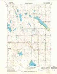
 1968 Lake Hassel1970 Print · USGSThe rural borderlands of Pope and Swift counties are shown in the late sixties, a landscape of prairie potholes and township grids. Genealogists can locate family landmarks like the Ellerson-Mortenson Cem, East Zion Ch, and the local Townhall.
 - 1968 Map of Benson, 1970 Print
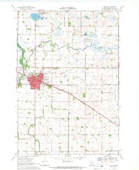 1968 Benson1970 Print · USGSBenson was a thriving rail hub in Swift County during the late sixties, centered on the Great Northern Railroad. Researchers can trace local genealogy and civic life through landmarks like St Francis Cem, School No 2191, and the Courthouse.
 - 1968 Map of Lake Simon, 1970 Print
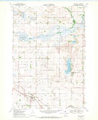
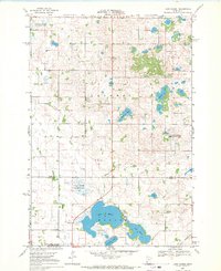
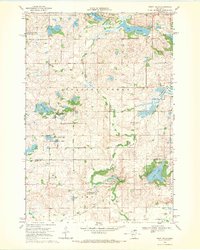
 1968 Lake Simon1970 Print · USGSCentral Minnesota's glacial prairie pothole region is captured here in the late sixties, showcasing a landscape defined by water and wildlife management. Local historians can trace family roots at the Lake Johanna Church, Cem West, and the rural Townhall.2 unique versions available
 - 1968 Map of Hancock SW, 1970 Print
 1968 Hancock SW1970 Print · USGSNear the Stevens and Swift county line in the late sixties, the village of Holloway stands as a rail hub along the Great Northern. Local historians can trace several pioneer burial grounds like Smith-Kepner Cem and Immanuel Cem near the winding Pomme De Terre River.2 unique versions available
 - 1968 Map of Clontarf North, 1970 Print
 1968 Clontarf North1970 Print · USGSPope and Swift Counties were defined by rail-side settlements and prairie wetlands in the late sixties. Genealogists and local historians can trace the foundations of Clontarf along the Great Northern tracks and locate family sites near St Malachy Cem.
 - 1968 Map of Hancock NW, 1970 Print
 1968 Hancock NW1970 Print · USGSStevens and Swift Counties are captured in the late sixties, showing a landscape defined by the Pomme De Terre River and rural townships. Genealogists can locate family landmarks like Zion Cem, the Apostolic Ch, and the settlement of Fairfield.2 unique versions available
 - 1968 Map of Swift Falls, 1970 Print
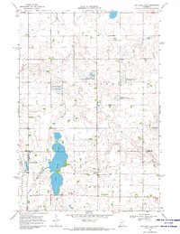
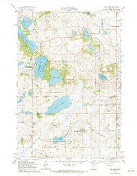
 1968 Swift Falls1970 Print · USGSIn the late sixties, the Swift Falls area was a mosaic of glacial lakes and prairie wetlands preserved by several wildlife management areas. Genealogists and historians can trace local landmarks like School No 2241, an Old Railroad Grade, and the Cem near Swift Falls.
 - 1968 Map of Clontarf South, 1970 Print
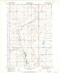
 1968 Clontarf South1970 Print · USGSSwift County agricultural and marshlands are captured here in the late sixties, where the Great Northern rail line skirts the Chippewa River. Researchers can trace the rural landscape near Clontarf, the Six Mile Grove Cem, and Lynch Lake.
 - 1968 Map of De Graff SE, 1970 Print
 1968 De Graff SE1970 Print · USGSThe prairie and pothole lakes of Swift and Kandiyohi Counties are captured here in the late sixties, showing a landscape shared by agriculture and conservation. Trace local family roots at Monson Lake Ch Cem, locate the rural Townhall, or explore the grounds of Monson Lake Memorial State Park.
End of results
Showing maps 1-14 of 14
Top cities of Swift County
- Benson historical maps
- Appleton historical maps
- Kerkhoven historical maps
- Murdock historical maps
- Clontarf historical maps
- Fairfield historical maps
See more
Frequently asked questions
- What are the different types of historical maps available for Swift County?
- What is the oldest map of Swift County?
- Where can I purchase historical maps of Swift County for my home or office?
- Where can I download high-res historical maps of Swift County?
- Are there historical topographic maps available for Swift County?
- Is there historical aerial imagery available for Swift County?
- Where are historical maps of Swift County sourced from?