1960s Maps of Holloway, Minnesota
Explore 1 historic maps of Holloway from the 1960s. These maps offer a rare glimpse into what life looked like during the 1960s — showing old roads, neighborhoods, homes, and landmarks that have changed or disappeared over time.
Whether you're researching your family's past, planning a metal detecting trip, or studying how Holloway's landscape evolved across the 1960s, these high-resolution maps are a powerful tool for exploring the history of this region.
- Focus on a specific era: All maps on this page are from the 1960s, giving you a focused view of this time period.
- See what’s changed: Compare century-old streets, trails, and buildings to today's modern landscape using overlays and satellite layers.
- Research with precision: Use these maps for genealogy, historical research, land use analysis, or educational projects.
- View, download, or print: Maps are fully viewable online in high resolution, and can be downloaded or printed for your own records.
Start exploring Holloway's history through authentic maps from the 1960s. This is your window into the past.
Holloway, MN maps
(1)- 1968 Map of Hancock SW, 1970 Print
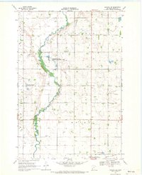 1968 Hancock SW1970 Print · USGSNear the Stevens and Swift county line in the late sixties, the village of Holloway stands as a rail hub along the Great Northern. Local historians can trace several pioneer burial grounds like Smith-Kepner Cem and Immanuel Cem near the winding Pomme De Terre River.2 unique versions available
End of results
Showing maps 1-1 of 1
Top cities near Holloway
- Appleton historical maps
- Milan historical maps
- Cerro Gordo historical maps
- Clontarf historical maps
- Fairfield historical maps
- Danvers historical maps
Frequently asked questions
- What are the different types of historical maps available for Holloway?
- What is the oldest map of Holloway?
- Where can I purchase historical maps of Holloway for my home or office?
- Where can I download high-res historical maps of Holloway?
- Are there historical topographic maps available for Holloway?
- Is there historical aerial imagery available for Holloway?
- Where are historical maps of Holloway sourced from?