1970s Maps of Browns Valley, Minnesota
Explore 2 historic maps of Browns Valley from the 1970s. These maps offer a rare glimpse into what life looked like during the 1970s — showing old roads, neighborhoods, homes, and landmarks that have changed or disappeared over time.
Whether you're researching your family's past, planning a metal detecting trip, or studying how Browns Valley's landscape evolved across the 1970s, these high-resolution maps are a powerful tool for exploring the history of this region.
- Focus on a specific era: All maps on this page are from the 1970s, giving you a focused view of this time period.
- See what’s changed: Compare century-old streets, trails, and buildings to today's modern landscape using overlays and satellite layers.
- Research with precision: Use these maps for genealogy, historical research, land use analysis, or educational projects.
- View, download, or print: Maps are fully viewable online in high resolution, and can be downloaded or printed for your own records.
Start exploring Browns Valley's history through authentic maps from the 1970s. This is your window into the past.
Browns Valley, MN maps
(2)- 1971 Map of Browns Valley, 1974 Print
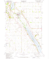 1971 Browns Valley1974 Print · USGSBrowns Valley occupied this critical continental divide in the early seventies, positioned between two major reservoirs at the Minnesota-South Dakota border. Researchers can trace the rail-and-water geography of the era, locating the Burlington Northern line, the Valley View Cem, and the Townhall.
 - 1977 Map of Browns Valley, 1979 Print
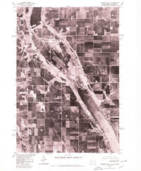 1977 Browns Valley1979 Print · USGSBrowns Valley occupies a unique position on the Continental Divide in the late seventies. Family historians and land researchers can trace the town layout and the precise banks of Big Stone Lake, Lake Traverse, and the Little Minnesota River.
End of results
Showing maps 1-2 of 2
Top cities near Browns Valley
- Sisseton historical maps
- Wilmot historical maps
- Beardsley historical maps
- Peever historical maps
- Old Agency District historical maps
- Spring Grove historical maps
See more
Frequently asked questions
- What are the different types of historical maps available for Browns Valley?
- What is the oldest map of Browns Valley?
- Where can I purchase historical maps of Browns Valley for my home or office?
- Where can I download high-res historical maps of Browns Valley?
- Are there historical topographic maps available for Browns Valley?
- Is there historical aerial imagery available for Browns Valley?
- Where are historical maps of Browns Valley sourced from?