1970s Maps of Kellogg, Minnesota
Explore 2 historic maps of Kellogg from the 1970s. These maps offer a rare glimpse into what life looked like during the 1970s — showing old roads, neighborhoods, homes, and landmarks that have changed or disappeared over time.
Whether you're researching your family's past, planning a metal detecting trip, or studying how Kellogg's landscape evolved across the 1970s, these high-resolution maps are a powerful tool for exploring the history of this region.
- Focus on a specific era: All maps on this page are from the 1970s, giving you a focused view of this time period.
- See what’s changed: Compare century-old streets, trails, and buildings to today's modern landscape using overlays and satellite layers.
- Research with precision: Use these maps for genealogy, historical research, land use analysis, or educational projects.
- View, download, or print: Maps are fully viewable online in high resolution, and can be downloaded or printed for your own records.
Start exploring Kellogg's history through authentic maps from the 1970s. This is your window into the past.
Kellogg, MN maps
(2)- 1974 Map of Wabasha South, 1976 Print
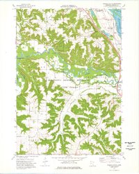 1974 Wabasha South1976 Print · USGSThe river bluffs and bottomlands of Wabasha County are captured here in the mid-seventies as the rail-and-river economy persists. Genealogy and local history enthusiasts can trace the Chicago Milwaukee St Paul and Pacific line through Wabasha, Midland Junction, and the St Agnes Cem near Kellogg.
 - 1974 Map of Alma, 1976 Print
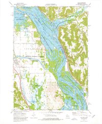 1974 Alma1976 Print · USGSThe Upper Mississippi River corridor is captured here in the mid-1970s, showing the intricate wetlands and industrial river crossings of the border region. You can trace the rail lines of the Burlington Northern and locate sites like Lock and Dam No 4 or the Mill Creek Cem.2 unique versions available
End of results
Showing maps 1-2 of 2
Top cities near Kellogg
- Plainview historical maps
- Wabasha historical maps
- Buffalo City historical maps
- Pepin historical maps
- Alma historical maps
- Rollingstone historical maps
See more
Frequently asked questions
- What are the different types of historical maps available for Kellogg?
- What is the oldest map of Kellogg?
- Where can I purchase historical maps of Kellogg for my home or office?
- Where can I download high-res historical maps of Kellogg?
- Are there historical topographic maps available for Kellogg?
- Is there historical aerial imagery available for Kellogg?
- Where are historical maps of Kellogg sourced from?