1960s Maps of Otisco, Minnesota
Explore 1 historic maps of Otisco from the 1960s. These maps offer a rare glimpse into what life looked like during the 1960s — showing old roads, neighborhoods, homes, and landmarks that have changed or disappeared over time.
Whether you're researching your family's past, planning a metal detecting trip, or studying how Otisco's landscape evolved across the 1960s, these high-resolution maps are a powerful tool for exploring the history of this region.
- Focus on a specific era: All maps on this page are from the 1960s, giving you a focused view of this time period.
- See what’s changed: Compare century-old streets, trails, and buildings to today's modern landscape using overlays and satellite layers.
- Research with precision: Use these maps for genealogy, historical research, land use analysis, or educational projects.
- View, download, or print: Maps are fully viewable online in high resolution, and can be downloaded or printed for your own records.
Start exploring Otisco's history through authentic maps from the 1960s. This is your window into the past.
Otisco, MN maps
(1)- 1967 Map of Otisco, 1969 Print
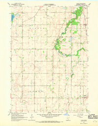 1967 Otisco1969 Print · USGSWaseca County's agricultural heartland is documented here in the late sixties as drainage projects and rail lines shaped the local economy. Researchers can locate family landmarks like St Peter Cem or trace the Chicago and North Western rail corridor through Otisco.
End of results
Showing maps 1-1 of 1
Top cities near Otisco
- Owatonna historical maps
- Waseca historical maps
- Wells historical maps
- Janesville historical maps
- New Richland historical maps
- Clarks Grove historical maps
See more
Frequently asked questions
- What are the different types of historical maps available for Otisco?
- What is the oldest map of Otisco?
- Where can I purchase historical maps of Otisco for my home or office?
- Where can I download high-res historical maps of Otisco?
- Are there historical topographic maps available for Otisco?
- Is there historical aerial imagery available for Otisco?
- Where are historical maps of Otisco sourced from?