1960s Maps of Waldorf, Minnesota
Explore 1 historic maps of Waldorf from the 1960s. These maps offer a rare glimpse into what life looked like during the 1960s — showing old roads, neighborhoods, homes, and landmarks that have changed or disappeared over time.
Whether you're researching your family's past, planning a metal detecting trip, or studying how Waldorf's landscape evolved across the 1960s, these high-resolution maps are a powerful tool for exploring the history of this region.
- Focus on a specific era: All maps on this page are from the 1960s, giving you a focused view of this time period.
- See what’s changed: Compare century-old streets, trails, and buildings to today's modern landscape using overlays and satellite layers.
- Research with precision: Use these maps for genealogy, historical research, land use analysis, or educational projects.
- View, download, or print: Maps are fully viewable online in high resolution, and can be downloaded or printed for your own records.
Start exploring Waldorf's history through authentic maps from the 1960s. This is your window into the past.
Waldorf, MN maps
(1)- 1967 Map of Waldorf, 1969 Print
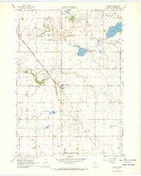 1967 Waldorf1969 Print · USGSWaldorf was a vital rail-side community in the late 1960s, surrounded by the meticulously drained fields of southern Minnesota. Researchers can locate numerous ancestral sites including Freedom Cem, Radloff Cem, and Immanuel Ch along the Chicago Milwaukee St Paul and Pacific line.
End of results
Showing maps 1-1 of 1
Top cities near Waldorf
- Mankato historical maps
- Waseca historical maps
- Wells historical maps
- Janesville historical maps
- Eagle Lake historical maps
- New Richland historical maps
See more
Frequently asked questions
- What are the different types of historical maps available for Waldorf?
- What is the oldest map of Waldorf?
- Where can I purchase historical maps of Waldorf for my home or office?
- Where can I download high-res historical maps of Waldorf?
- Are there historical topographic maps available for Waldorf?
- Is there historical aerial imagery available for Waldorf?
- Where are historical maps of Waldorf sourced from?