1980s Maps of Rockford Township, Minnesota
Explore 7 historic maps of Rockford Township from the 1980s. These maps offer a rare glimpse into what life looked like during the 1980s — showing old roads, neighborhoods, homes, and landmarks that have changed or disappeared over time.
Whether you're researching your family's past, planning a metal detecting trip, or studying how Rockford Township's landscape evolved across the 1980s, these high-resolution maps are a powerful tool for exploring the history of this region.
- Focus on a specific era: All maps on this page are from the 1980s, giving you a focused view of this time period.
- See what’s changed: Compare century-old streets, trails, and buildings to today's modern landscape using overlays and satellite layers.
- Research with precision: Use these maps for genealogy, historical research, land use analysis, or educational projects.
- View, download, or print: Maps are fully viewable online in high resolution, and can be downloaded or printed for your own records.
Start exploring Rockford Township's history through authentic maps from the 1980s. This is your window into the past.
Rockford Township, MN maps
(7)- 1981 Map of St Michael
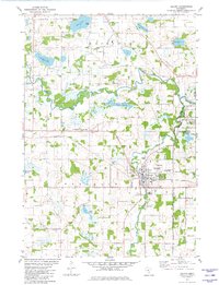
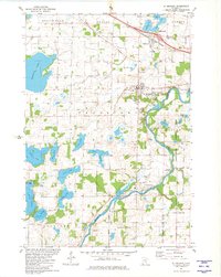 1981 St Michael1981 Print · USGSIn the early 1980s, the growing communities of St Michael and Albertville were still defined by their local institutions and lakeside geography. Genealogists and historians can trace family locations through St Albert Cem, St Michael Cem, and the historic Berning Mill along the Crow River.
 - 1981 Map of Rockford
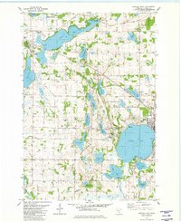
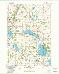 1981 Rockford1981 Print · USGSCentral Minnesota lake country is captured here in the early eighties as the Crow River and the Burlington Northern railroad shaped local growth. Researchers can locate family sites near Burschville, Loretto, or the SS Peter & Paul Cem.2 unique versions available
 - 1981 Map of Waverly, 1982 Print
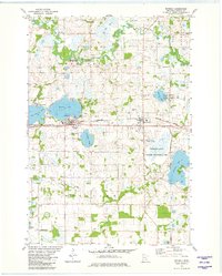 1981 Waverly1982 Print · USGSWright County is captured here in the early 1980s as its agricultural roots and railway corridors remained central to local life. Genealogists and local historians can locate several parish landmarks and cemeteries, including Swedesburg Ch, Mission Cem, and Wright Cem.
 - 1981 Map of Buffalo East, 1982 Print
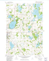 1981 Buffalo East1982 Print · USGSWright County is revealed in the early 1980s as a landscape of interconnected glacial lakes and established township settlements. Local historians can trace the Soo Line rail corridor and find old burial sites like St Marks Cem and Lakeview Cem.
 - 1981 Map of Buffalo West, 1982 Print
 1981 Buffalo West1982 Print · USGSWright County’s lake country is captured in the early eighties as the communities of Buffalo and Maple Lake grew around their namesake waters. Researchers can trace the Old Railroad Grade or locate historic burial sites like Old St Timothy Cem and St Charles Cem.
 - 1981 Map of Delano, 1982 Print
 1981 Delano1982 Print · USGSThe Crow River forks and the bustling town of Delano are captured in the early eighties. Genealogists can trace family names across nearly a dozen sites, including Cassel Cem, St Peters Cem, and St Josephs Cem.
 - 1985 Map of Anoka
 1985 Anoka1985 Print · USGSThe northern Twin Cities suburbs and the Mississippi River valley are captured here in the mid-eighties as suburban growth began to meet rural conservation lands. Trace the expansion of Anoka and Blaine, or locate family landmarks near the Rum River and Buffalo Lake.
End of results
Showing maps 1-7 of 7
Top cities near Rockford Township
- Chanhassen historical maps
- Elk River historical maps
- St. Michael historical maps
- Saint Michael historical maps
- Buffalo historical maps
- Rogers historical maps
See more
Frequently asked questions
- What are the different types of historical maps available for Rockford Township?
- What is the oldest map of Rockford Township?
- Where can I purchase historical maps of Rockford Township for my home or office?
- Where can I download high-res historical maps of Rockford Township?
- Are there historical topographic maps available for Rockford Township?
- Is there historical aerial imagery available for Rockford Township?
- Where are historical maps of Rockford Township sourced from?