1960s Maps of Kienstra, Mississippi
Explore 2 historic maps of Kienstra from the 1960s. These maps offer a rare glimpse into what life looked like during the 1960s — showing old roads, neighborhoods, homes, and landmarks that have changed or disappeared over time.
Whether you're researching your family's past, planning a metal detecting trip, or studying how Kienstra's landscape evolved across the 1960s, these high-resolution maps are a powerful tool for exploring the history of this region.
- Focus on a specific era: All maps on this page are from the 1960s, giving you a focused view of this time period.
- See what’s changed: Compare century-old streets, trails, and buildings to today's modern landscape using overlays and satellite layers.
- Research with precision: Use these maps for genealogy, historical research, land use analysis, or educational projects.
- View, download, or print: Maps are fully viewable online in high resolution, and can be downloaded or printed for your own records.
Start exploring Kienstra's history through authentic maps from the 1960s. This is your window into the past.
Kienstra, MS maps
(2)- 1965 Map of Lake Mary, 1966 Print
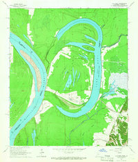 1965 Lake Mary1966 Print · USGSThe oxbows and river bends of Wilkinson County are captured here in the mid-1960s as the river economy transitions toward oil extraction. Genealogists and researchers can trace rural landmarks like Artonish, the Hollywood Sch, and the Loch Leven Cem.
 - 1967 Map of Artonish, 1968 Print
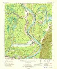 1967 Artonish1968 Print · USGSThe river country of the Mississippi-Louisiana border is captured here during a period of massive hydraulic engineering. Genealogists and researchers can locate historic sites like Fort Adams, the Lake Mary Oil Field, and family burial grounds such as Good Hope Cem and Ward Cem.
End of results
Showing maps 1-2 of 2
Frequently asked questions
- What are the different types of historical maps available for Kienstra?
- What is the oldest map of Kienstra?
- Where can I purchase historical maps of Kienstra for my home or office?
- Where can I download high-res historical maps of Kienstra?
- Are there historical topographic maps available for Kienstra?
- Is there historical aerial imagery available for Kienstra?
- Where are historical maps of Kienstra sourced from?