1960s Maps of Cleveland Crossing, Mississippi
Explore 2 historic maps of Cleveland Crossing from the 1960s. These maps offer a rare glimpse into what life looked like during the 1960s — showing old roads, neighborhoods, homes, and landmarks that have changed or disappeared over time.
Whether you're researching your family's past, planning a metal detecting trip, or studying how Cleveland Crossing's landscape evolved across the 1960s, these high-resolution maps are a powerful tool for exploring the history of this region.
- Focus on a specific era: All maps on this page are from the 1960s, giving you a focused view of this time period.
- See what’s changed: Compare century-old streets, trails, and buildings to today's modern landscape using overlays and satellite layers.
- Research with precision: Use these maps for genealogy, historical research, land use analysis, or educational projects.
- View, download, or print: Maps are fully viewable online in high resolution, and can be downloaded or printed for your own records.
Start exploring Cleveland Crossing's history through authentic maps from the 1960s. This is your window into the past.
Cleveland Crossing, MS maps
(2)- 1967 Map of Skene, 1968 Print
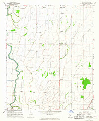 1967 Skene1968 Print · USGSThe Bolivar County delta in the late sixties shows a landscape of intricate drainage canals and small farming hubs. Genealogists can locate family-named landmarks like Litton and Laughlin or trace rural congregations such as Damascus Ch and New St James Ch.
 - 1969 Map of Choctaw
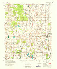 1969 Choctaw1969 Print · USGSBolivar County at the end of the 1960s reveals a Delta landscape shaped by complex bayou drainage and a dense network of country churches. Researchers can trace family sites near Stringtown and Meltonia or locate landmarks like the Gospel Temple and Indian Mound 26.
End of results
Showing maps 1-2 of 2
Top cities near Cleveland Crossing
- Cleveland historical maps
- Shelby historical maps
- Mound Bayou historical maps
- Shaw historical maps
- Rosedale historical maps
- Boyle historical maps
See more
Frequently asked questions
- What are the different types of historical maps available for Cleveland Crossing?
- What is the oldest map of Cleveland Crossing?
- Where can I purchase historical maps of Cleveland Crossing for my home or office?
- Where can I download high-res historical maps of Cleveland Crossing?
- Are there historical topographic maps available for Cleveland Crossing?
- Is there historical aerial imagery available for Cleveland Crossing?
- Where are historical maps of Cleveland Crossing sourced from?