1930s Maps of Cleveland, Mississippi
Explore 5 historic maps of Cleveland from the 1930s. These maps offer a rare glimpse into what life looked like during the 1930s — showing old roads, neighborhoods, homes, and landmarks that have changed or disappeared over time.
Whether you're researching your family's past, planning a metal detecting trip, or studying how Cleveland's landscape evolved across the 1930s, these high-resolution maps are a powerful tool for exploring the history of this region.
- Focus on a specific era: All maps on this page are from the 1930s, giving you a focused view of this time period.
- See what’s changed: Compare century-old streets, trails, and buildings to today's modern landscape using overlays and satellite layers.
- Research with precision: Use these maps for genealogy, historical research, land use analysis, or educational projects.
- View, download, or print: Maps are fully viewable online in high resolution, and can be downloaded or printed for your own records.
Start exploring Cleveland's history through authentic maps from the 1930s. This is your window into the past.
Cleveland, MS maps
(5)- 1931 Map of Drew
 1931 Drew1931 Print · USGSSunflower County's agricultural and social landscape is meticulously detailed in the early 1930s, centering on the communities of Mound Bayou and Drew. Researchers can trace the layout of the State Penitentiary Reservation and numerous country churches like Beautiful Star Ch and Shady Grove Ch.
 - 1934 Map of Cleveland
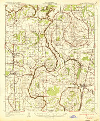
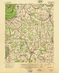
 1934 Cleveland1934 Print · USGSThe Mississippi Delta in the early thirties was a bustling landscape of rail-connected plantation towns and rural schools. Genealogists can trace family roots through numerous sites like Boyer Cem, the Doddsville Industrial Institute, and the historic Dockery community.2 unique versions available
 - 1935 Map of Mound Bayou
 1935 Mound Bayou1935 Print · USGSThe Mississippi Delta's agricultural and social landscape is captured here in the mid-1930s as local communities thrived along the rail lines. Genealogists can locate family landmarks like Pilgrims Rest Ch or trace the extensive camp system of the State Reservation.2 unique versions available
 - 1939 Map of Pace, 1942 Print
 1939 Pace1942 Print · USGSBolivar County in the late 1930s is a landscape of thriving Delta towns and extensive plantation land. Genealogists can locate family landmarks like Kirks Plantation, the Beulah Cem, and rural churches such as Pitts Chapel and Macedonia Ch.2 unique versions available
 - 1939 Map of Choctaw, 1965 Print
 1939 Choctaw1965 Print · USGSBolivar County and Washington County are captured here at the end of the 1930s, showing a Delta landscape transformed by drainage canals and rail. You can trace early twentieth-century settlement patterns through landmarks like Mt Olive Ch, the Illinois Central Railroad corridor, and the community at Shaw.
End of results
Showing maps 1-5 of 5
Top cities near Cleveland
- Ruleville historical maps
- Shelby historical maps
- Drew historical maps
- Mound Bayou historical maps
- Shaw historical maps
- Boyle historical maps
See more
Frequently asked questions
- What are the different types of historical maps available for Cleveland?
- What is the oldest map of Cleveland?
- Where can I purchase historical maps of Cleveland for my home or office?
- Where can I download high-res historical maps of Cleveland?
- Are there historical topographic maps available for Cleveland?
- Is there historical aerial imagery available for Cleveland?
- Where are historical maps of Cleveland sourced from?