1960s Maps of Duncan, Mississippi
Explore 5 historic maps of Duncan from the 1960s. These maps offer a rare glimpse into what life looked like during the 1960s — showing old roads, neighborhoods, homes, and landmarks that have changed or disappeared over time.
Whether you're researching your family's past, planning a metal detecting trip, or studying how Duncan's landscape evolved across the 1960s, these high-resolution maps are a powerful tool for exploring the history of this region.
- Focus on a specific era: All maps on this page are from the 1960s, giving you a focused view of this time period.
- See what’s changed: Compare century-old streets, trails, and buildings to today's modern landscape using overlays and satellite layers.
- Research with precision: Use these maps for genealogy, historical research, land use analysis, or educational projects.
- View, download, or print: Maps are fully viewable online in high resolution, and can be downloaded or printed for your own records.
Start exploring Duncan's history through authentic maps from the 1960s. This is your window into the past.
Duncan, MS maps
(5)- 1960 Map of Helena
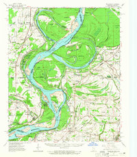
 1960 Helena1960 Print · USGSThe Arkansas and Mississippi Delta regions meet along the great river bends during a period of significant agricultural and rail expansion. Genealogists and historians can trace the paths of the Missouri Pacific railroad through Clarendon or locate landings along the Mississippi River and White River.
 - 1961 Map of Mellwood, 1965 Print
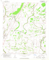
 1961 Mellwood1965 Print · USGSThe Mississippi River delta in the early sixties was a landscape shaped by recent engineering and historic floods. Researchers can trace the results of the Knowlton Crevasse (1912) and locate vanished landmarks like Zion Traveler Ch or Laconia Circle.
 - 1962 Map of Mellwood
 1962 Mellwood1962 Print · USGSThe Mississippi Delta's shifting riverbanks and floodplain communities are captured here in the early sixties. Genealogists and historians can trace family landmarks like the Zion Traveler Cem, the Laconia Crevasse (1913), and the settlement of Mellwood.
 - 1967 Map of Duncan, 1968 Print
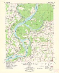
 1967 Duncan1968 Print · USGSThe Bolivar County Delta is captured in the late 1960s, showing a landscape defined by meandering bayous and the Illinois Central rail line. Genealogists can trace family roots through numerous local landmarks like Sanders Cem and Niland Chapel.2 unique versions available
 - 1968 Map of Clarksdale
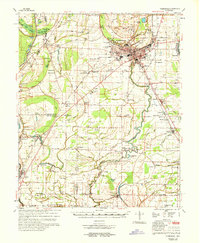 1968 Clarksdale1968 Print · USGSThe Mississippi Delta in the late sixties reveals a landscape shaped by the Sunflower River and rail industry. Genealogists can trace family roots at Pleasant Grove Cem, the Africa-Roundaway Sch, and rural landmarks like Morning Glory Ch.
End of results
Showing maps 1-5 of 5
Top cities near Duncan
- Clarksdale historical maps
- Shelby historical maps
- Drew historical maps
- Mound Bayou historical maps
- Merigold historical maps
- Lyon historical maps
See more
Frequently asked questions
- What are the different types of historical maps available for Duncan?
- What is the oldest map of Duncan?
- Where can I purchase historical maps of Duncan for my home or office?
- Where can I download high-res historical maps of Duncan?
- Are there historical topographic maps available for Duncan?
- Is there historical aerial imagery available for Duncan?
- Where are historical maps of Duncan sourced from?