1930s Maps of Duncan, Mississippi
Explore 4 historic maps of Duncan from the 1930s. These maps offer a rare glimpse into what life looked like during the 1930s — showing old roads, neighborhoods, homes, and landmarks that have changed or disappeared over time.
Whether you're researching your family's past, planning a metal detecting trip, or studying how Duncan's landscape evolved across the 1930s, these high-resolution maps are a powerful tool for exploring the history of this region.
- Focus on a specific era: All maps on this page are from the 1930s, giving you a focused view of this time period.
- See what’s changed: Compare century-old streets, trails, and buildings to today's modern landscape using overlays and satellite layers.
- Research with precision: Use these maps for genealogy, historical research, land use analysis, or educational projects.
- View, download, or print: Maps are fully viewable online in high resolution, and can be downloaded or printed for your own records.
Start exploring Duncan's history through authentic maps from the 1930s. This is your window into the past.
Duncan, MS maps
(4)- 1930 Map of Mellwood
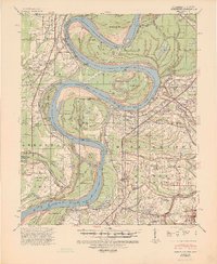
 1930 Mellwood1930 Print · USGSThe Mississippi Delta's shifting banks and rail-tied settlements are frozen in time just before the great mid-century levee expansions. Trace the history of the 1910s floods via the Ferguson Crevasse and locate river-dependent towns like Mellwood and Deeson.
 - 1935 Map of Clarksdale
 1935 Clarksdale1935 Print · USGSThe Mississippi Delta's cotton country is captured here in the mid-1930s as the rail-and-river economy flourished. Genealogists can locate numerous rural landmarks like the Rosenwald Sch, Stoverville, and old church sites such as Beautiful Zion Ch.2 unique versions available
 - 1939 Map of Clarksdale, 1943 Print
 1939 Clarksdale1943 Print · USGSThe Mississippi Delta's agricultural and social landscape is captured here during the late 1930s. Genealogists can trace family roots through numerous local landmarks, including the Rosenwald Sch, Beautiful Zion Ch, and rural stations like Beverly Davenport Sta.
 - 1939 Map of Mellwood, 1946 Print
 1939 Mellwood1946 Print · USGSThe Mississippi River Delta of the late thirties reveals a landscape of massive levee projects and rail-dependent river towns. Genealogists can trace family roots through numerous rural church sites and burial grounds like Jerusalem Ch & Cem, St Joseph Ch & Cem, and the unique Laconia Circle.2 unique versions available
End of results
Showing maps 1-4 of 4
Top cities near Duncan
- Clarksdale historical maps
- Shelby historical maps
- Drew historical maps
- Mound Bayou historical maps
- Merigold historical maps
- Lyon historical maps
See more
Frequently asked questions
- What are the different types of historical maps available for Duncan?
- What is the oldest map of Duncan?
- Where can I purchase historical maps of Duncan for my home or office?
- Where can I download high-res historical maps of Duncan?
- Are there historical topographic maps available for Duncan?
- Is there historical aerial imagery available for Duncan?
- Where are historical maps of Duncan sourced from?