
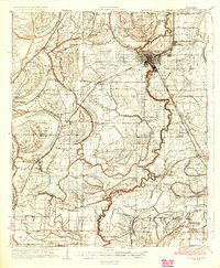
1935 Map of Clarksdale
USGS Topo · Published 1935About this map
Clarksdale serves as the focal point of this mid-1930s landscape, where the Sunflower River and the Yazoo and Mississippi Valley Railroad converge to drive the regional economy. The map reveals a dense network of plantation life and small agrarian communities, many organized around cotton ginning and rail access. Notable for genealogists are the numerous rural institutions, including the Rosenwald Sch and Hilliard Sch, alongside an exceptional concentration of country churches like Beautiful Zion Ch, Mt Zion Ch, and St Pauls Ch. The terrain is defined by the intricate hydrology of the Delta, with Roundaway Bayou, Annis Bayou, and Turkey Bayou winding through the alluvial plain. Smaller stops such as Sherard, Lyon, and the community of Africa illustrate the early 20th-century settlement patterns before modern agricultural mechanization fully reshaped the region.
Find a feature on this map
99 named features on this map. Tap any name to fly to it.
Don’t see what you’re looking for? This feature index may not catch every label — zoom into the map to look around manually.
Map Details
Editions of this 1935 Clarksdale Map
2 editions found
Other maps of this area

1908 · Coahoma
USGS Topo · 1:24,000

1908 · Jonestown
USGS Topo · 1:24,000

1910 · Coahoma
USGS Topo · 1:31,680

1910 · Jonestown
USGS Topo · 1:31,680

1930 · Mellwood
USGS Topo · 1:62,500

1931 · Sumner
USGS Topo · 1:48,000

1931 · Drew
USGS Topo · 1:48,000

1932 · Tutwiler
USGS Topo · 1:48,000

1932 · Marks
USGS Topo · 1:48,000

1935 · Marks
USGS Topo · 1:62,500