
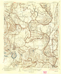
1935 Map of Marks
USGS Topo · Published 1935About this map
The Coldwater River snakes through this Delta landscape, defining a complex network of bayous and oxbow lakes like Bear Lake and Long Lake. The map reveals a dense social infrastructure of small settlements and rural centers during the mid-1930s, marked by a high concentration of community landmarks such as Swan Lake College and the Posey Mound. This era was characterized by an intensive pattern of small churches and schools, including Jones Chapel, Robinson Chapel, and the Arkadelphia Sch, which served the scattered agricultural population. The proximity of the County Farm and various brakes like Carr Brake reflects the managed rural economy of the time. Transport is anchored by the Yazoo And Mississippi Valley railroad, which links the towns of Lula, Jonestown, and Marks. The presence of Jazzland and Flea Harbor provides a glimpse into the local place-naming traditions of the Mississippi Delta.
Find a feature on this map
109 named features on this map. Tap any name to fly to it.
Don’t see what you’re looking for? This feature index may not catch every label — zoom into the map to look around manually.
Map Details
Editions of this 1935 Marks Map
2 editions found
Other maps of this area

1908 · Lula
USGS Topo · 1:24,000

1908 · Dundee
USGS Topo · 1:24,000

1908 · Coahoma
USGS Topo · 1:24,000

1908 · Moon Lake
USGS Topo · 1:24,000

1908 · Jonestown
USGS Topo · 1:24,000

1908 · Walnut Lake
USGS Topo · 1:24,000

1910 · Dundee
USGS Topo · 1:31,680

1910 · Coahoma
USGS Topo · 1:31,680

1910 · Walnut Lake
USGS Topo · 1:31,680

1910 · Jonestown
USGS Topo · 1:31,680